The GOLIA project , which kicked off in June 2025, is a three-year Research and Innovation Actions (RIA) Horizon Europe project, coordinated by FIT Consulting and funded by the European Union under the topic, HORIZON-CL5-2024-D6-01-09: Policies and governance shaping the future transport and mobility systems. The overarching goal of GOLIA is to develop an integrated, interdisciplinary Smart Mobility Governance Model, relying on a data-based and social optimum-driven approach and inclusive policy making processes to ensure an adaptive, accessible and just mobility system.
Project Description
GOLIA is a project focused on Governing, Optimising and Leveraging Innovation in cities through data-driven and social-optimum led approach. It aims to ensure an adaptive, accessible and just mobility system planned and governed with the help of digital assets, but also with the inclusive and co-creational policy making processes. Through the integration of STEM and SSH expertise and approaches, GOLIA will revolutionize spatial and mobility planning by co-developing and testing vision-led Social Optimum Mobility Index, a metric to assess urban mobility systems based not only on economic variables but also on indicators such as social support, healthy life quality or freedom to make life choices. The index will be location and time dependent to enable dynamic management of transport offer and spaces.
The project will analyse the policy making processes, citizen engagement practices and digital assets of the three Partner cities and with the gained knowledge, it will create an integrated, interdisciplinary and Adaptive Mobility Smart Governance Model. GOLIA aims at understanding to which extent and under which conditions, data generated by Smart Cities supported by AI-based tools novel communication and consultation channels and methodologies to engage citizens and stakeholders might foster the establishment of a new inclusive and adaptive mobility governance. GOLIA’s goal is to identify governance models able to deliver policies resilient to political instability, extreme weather events, pandemics or any other more or less disruptive event, as they are co-developed, co-designed, and co-monitored by and for citizens and firms.
Consortium and Partners
The GOLIA project brings together 21 partners from 11 European countries, including universities, research institutes, private companies, associations, and city administrations. The consortium spans expertise in mobility planning, ICTs, artificial intelligence, logistics, parking management, and public transport. Florence, Antwerp, and Pilsen serve as the project’s partner cities, where innovative approaches will be tested to shape future-proof, user-centered mobility systems through data-driven governance and socially inclusive design.
Transform Transport’s Role
Transform Transport (TT)’s contribution is spread throughout the project. The focus lies in supporting the integration of rights-based approaches in mobility, assessing mobility impacts on the Social Optimum Mobility Index (SOMI) determinants, and co-developing digital mapping tools for the partner cities’ existing digital assets.
Transform Transport will bring its expertise and knowhow from multiple projects and ongoing initiatives to GOLIA, including:
- Expertise in transport poverty frameworks and index development
- Co-launched the Transport Poverty Lab with Fondazione per lo sviluppo sostenibile to support evidence-based policies and collaboration on transport poverty, with backing from several national ministries.
- Created a composite index combining PTAL and social vulnerability metrics to identify areas with overlapping mobility and social vulnerability conditions.
- Expertise in developing and automating scalable, data-driven mobility metrics
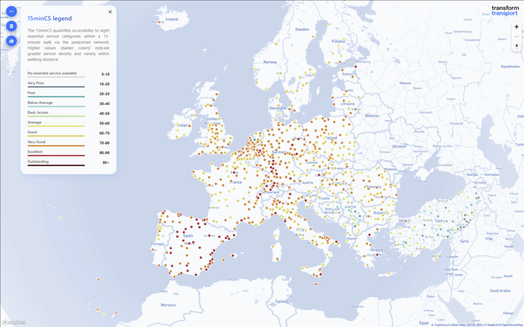
- Developed the 15-min City Score Toolkit, an open-source Python tool using OSM data to measure walkable service access in 100+ cities; now refined with population-weighted scoring and developed into an interactive online tool, the 15 Minute City Score Europe Map, covering the entire European region.
- Expertise in data visualization for stakeholder engagement and public use
- Built a portfolio of interactive GIS platforms like the 15 Minute City Score Europe Map, and the STEP UP Safety Index Map to communicate project findings through accessible, intuitive and engaging visual tools.
The project is currently in its early stages, laying the groundwork for development between the partners on the central themes of the project. As the project moves forward, this page will be updated to reflect key insights, milestones and results of this three-year, multi-stakeholder project.
Acknowledgements
This research is funded by the European Union, under the project title, Governing, Optimising and Leveraging Innovations proActively for shaping future proof holistic mobility system through data-driven and social optimum-led model, Grant no. 101201950.