
The “Tracce” project explores the theme of accessibility for people with reduced mobility in the city of Monza through an innovative methodology centered on user experience. The aim of the project is to develop a reference framework on the level of accessibility of pedestrian infrastructure, in order to facilitate urban design processes useful for defining the Urban Plan for the Elimination of Architectural Barriers (PEBA). Through a process of listening and participation involving citizens and local associations, the project focuses on mapping the factors that limit the mobility autonomy of people with reduced mobility, with the goal of developing a Web App for route planning and the reporting of critical issues.
Introduction
Inclusive urban accessibility is a key issue in ensuring the quality of life for all citizens, with special attention to those with mobility impediments, such as people with disabilities, the elderly, children, and parents. At the European level, several directives and initiatives promote urban accessibility, emphasizing the importance of integrating this issue into spatial development policies. Among these, the United Nations Convention on the Rights of Persons with Disabilities (United Nations, 2006[AT1] ), ratified by the EU, is a key reference point. The European Union has also adopted the European Strategy for the Rights of Persons with Disabilities 2021-2030 (European Commission, 2021), which aims to promote the inclusion and participation of people with disabilities in all aspects of life, including urban accessibility. In 2021, the Regione Lombardia approved Regional Government Resolution (DGR) No. XI/5555 of 23 November 2021, which defines the Guidelines for the preparation of PEBA – Plans for the Accessibility and Usability of the Built Environment (Regione Lombardia, 2021). The regulation provides guidance to local authorities on accessibility of spaces, services, and the built environment, with reference to the entire population.
Accessibility is a broad concept that refers to the ease with which people can reach and use services, resources, and environments. When focusing specifically on accessibility for people with mobility impairments, the definition emphasizes the need for urban environments to accommodate individuals with physical limitations, ensuring that they can move through public spaces, access transportation, and use facilities without encountering barriers (Steels, 2015). Measures to be taken include the provision of elements such as ramps, elevators, and accessible public transportation options, which are essential to ensure that people with reduced mobility can fully participate in community life, public space, but also public transportation services (Sze & Christensen, 2017).
Enabling Data and Methodology
The project, based on the Sustainable Urban Mobility Plan of the City of Monza, aims to analyze urban mobility in the city of Monza by focusing on the experience of users with reduced mobility, it will be developed through UX methodology, developed by Systematica and Transform Transport (2025), which refers to the quality of interaction between the user and the system that enables the user to achieve a specific goal (Dickson-Deane & Chen, 2018). UX in urban design extends Human-Computer Interaction (HCI) principles to the built environment, emphasizing a user-centered approach to mapping and analyzing urban mobility. The focus on urban experience through participatory activities captures the needs, expectations, feelings and perceptions of urban users, particularly those in vulnerable situations.

The project focuses on mapping factors that limit the autonomy in mobility of people with disabilities with the aim of developing a Web App for user route planning. The project methodology is divided in three main parts (see Figure 1):
- Listening and participation, focused on participatory planning through survey and workshops, with the aim of reaching a holistic understanding of the needs of people with disabilities and mobility impairments, living in the city of Monza;
- Mapping, based on the quantitative data collection, obtained through existing geolocated datasets and techniques of image segmentation algorithms, to map the presence of factors influencing user experience;
- Web App development, development of a customized routing system, accessible for free online from fixed and mobile devices, capable of generating optimized routes based on user preferences.
The final objective is to support the decision-making processes of the municipal administration and urban planners of the city of Monza by providing data, metrics, and tools to assist in planning interventions aimed at making the city more accessible and inclusive.
Participatory process
Participatory design was developed with the aim of building a structured and inclusive process for engaging the citizens of Monza, promoting continuous dialogue between the community, institutions, and the project. Active listening becomes a central element of the process to understand needs related to urban mobility, capable of strengthening the principles of inclusion and accessibility, while enhancing the experiential knowledge of citizens and the associations involved.
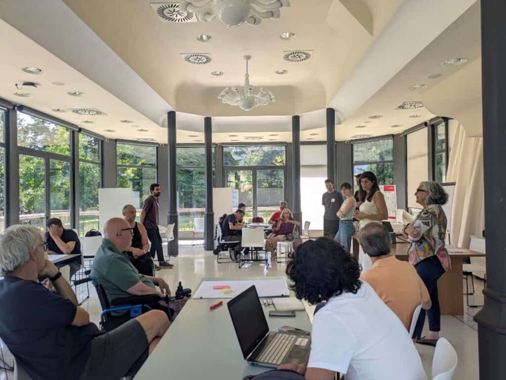
The core of the project’s participatory process is structured around three workshops, held between March and November 2025, during which the research results were translated into operational guidelines and shared solutions. Community involvement in Monza, supported by the municipality, included the participation of people with reduced mobility, caregivers, and representatives of advisory councils. The first workshop was dedicated to a guided discussion on everyday mobility experiences, aimed at bringing out barriers, facilitators, and emotional experiences related to urban space, and at providing concrete indications for mapping critical issues.


Figure 2 First participatory design workshop
The second workshop explored the theme of the usefulness and usability of a digital tool, involving participants in defining the functionalities of a Web App dedicated to accessible mobility, with particular attention to autonomy, personalization, and information quality.
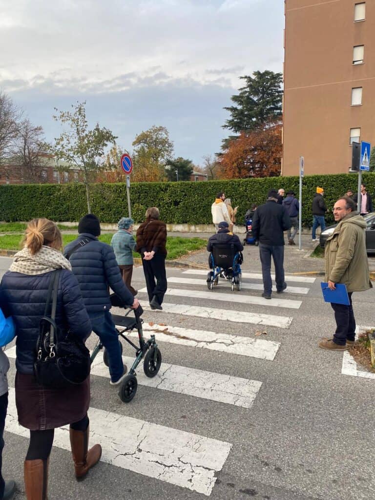
The third workshop represented a phase of field experimentation, combining the use of the Web App in indoor settings and in urban space, through participatory mapping of the neighborhood. This process made it possible to verify the effectiveness of the tool under everyday conditions, collecting targeted feedback on the interface, routing, and reporting features.
The participatory process was then accompanied by the design and dissemination of a questionnaire addressed to citizens, which collected 220 responses. The results of the questionnaire analyses provided a comprehensive and detailed overview of everyday difficulties related to urban mobility.
Overall, the results of the participatory process show that the main critical issues are often systemic and related to the routine management of public space, highlighting the need for tools capable of integrating structural data and dynamic reports, in order to support continuous and participatory monitoring of accessibility.
Mapping
The mapping activity aims to describe in a concrete and detailed manner the level of accessibility of the city of Monza for people with reduced mobility. The selection of indicators was guided by the UX Mobility methodology and refined through dialogue with citizens during the first workshop, which made it possible to identify the elements relevant to the local context.
The collection of geospatial data, carried out between April and May 2025, integrated open-source sources (e.g., OSM–OpenStreetMap, SIT Geoportal, etc.), proprietary archives made available by Monza Mobilità S.r.l. and the Municipality, and original datasets produced through field surveys and spatial analyses. Alongside already available datasets (e.g., public lighting, traffic accidents, etc.), the project developed more detailed structured data, such as the pedestrian graph derived from OSM, built to accurately represent the sidewalk network.
A second line of work experimented with the automated detection of architectural barriers through advanced Artificial Intelligence techniques for image segmentation using Google Street View imagery (Hara et al., 2014). The analysis focused specifically on the localization of ramps and crossings. The experimentation highlighted interesting potential for faster and more scalable mapping, but also limitations related to image quality and model variability.


Figure 6 Example of Google Street View image segmentation. Image © Google.
The collected data were used to build a multilevel map representing the structure of the pedestrian network and the main critical issues that compromise its continuity, accessibility, and safety. Mapping of the pedestrian network was developed through the integration of information characterizing routes, such as the presence of ramps near crossings, sidewalk width, public lighting, and traffic accident data. These elements formed the basis for analyses of crossing conditions and network completeness, as well as for advanced assessments aimed at measuring the detours imposed on users with reduced mobility and identifying priority nodes and segments.
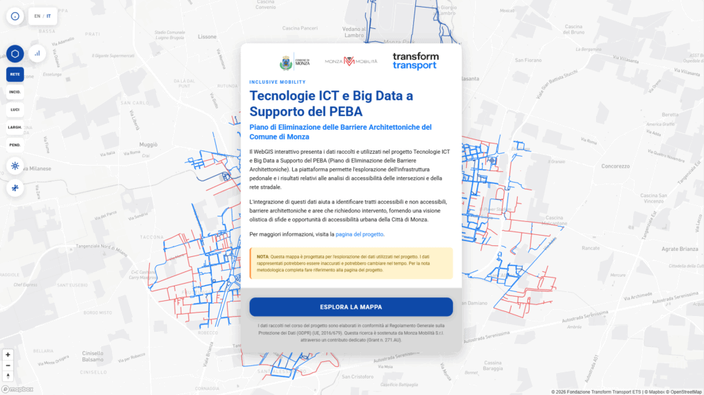
The WebGIS developed for the project is a interactive, bilingual platform that allows users to dynamically visualize and query the pedestrian network, filter data, read indicators and critical issues, and understand intervention priorities through maps and immediate summaries. This tool has the potential to become a decision-support and public communication device, capable of making the complexity of urban accessibility legible and facilitating more informed and inclusion-oriented planning.
Tracce.app
The Web App Tracce was developed to increase the autonomy of people with reduced mobility and those who accompany them, reducing uncertainty in travel and transforming everyday experience into useful data for understanding, monitoring, and improving urban accessibility. The interface is designed to be simple and intuitive; following profiling, users gain access to the app’s functionalities, which serve a dual purpose:
- Routing: the Web App helps plan routes by taking into account accessibility-related constraints and preferences;
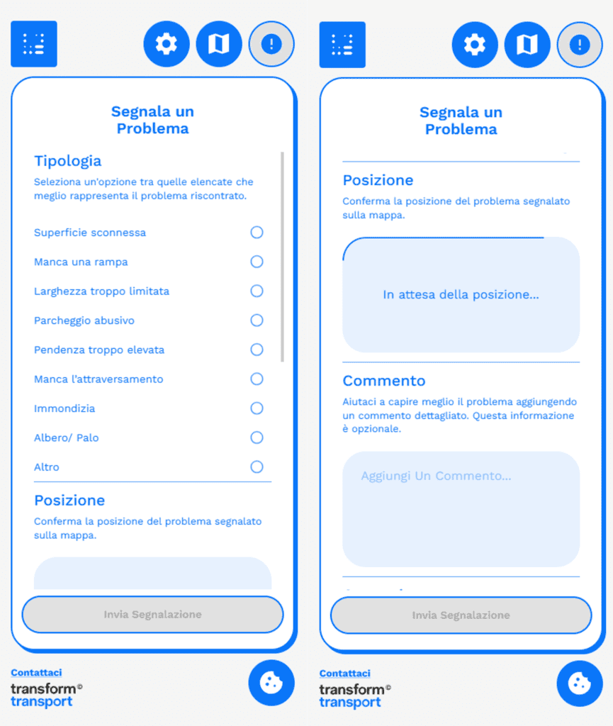
- Reporting: the Web App allows users to contribute geolocated reports, transforming everyday experience into useful data to improve over time the analyses supporting the Municipality of Monza and the further development of the app itself.
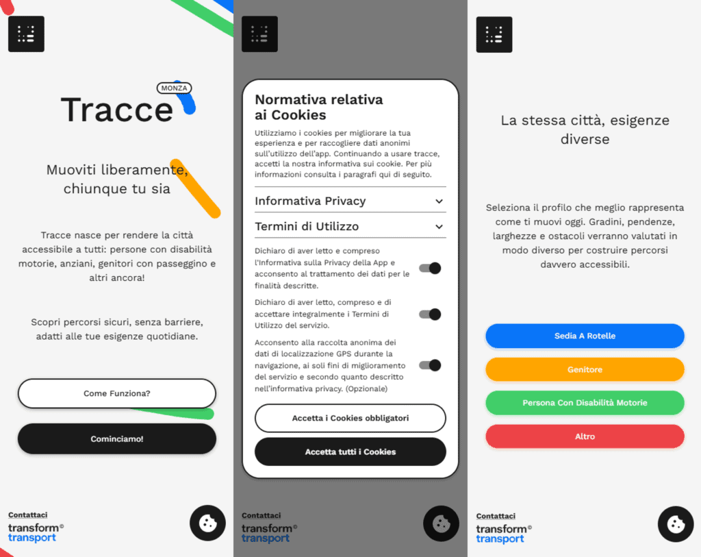
The Routing functionality makes it possible to plan pedestrian routes by comparing, for the same starting and ending points, two alternatives: a “fast” route, mainly based on distance, and an “accessible” route, designed to respond to the needs of people with reduced mobility. By selecting a profile, users customize certain parameters that are translated into exclusion constraints and route preferences, favoring alternatives consistent with the specified needs. If no route fully compatible with the selected criteria exists, the app informs the user and nevertheless ensures service continuity by displaying the shortest available route.
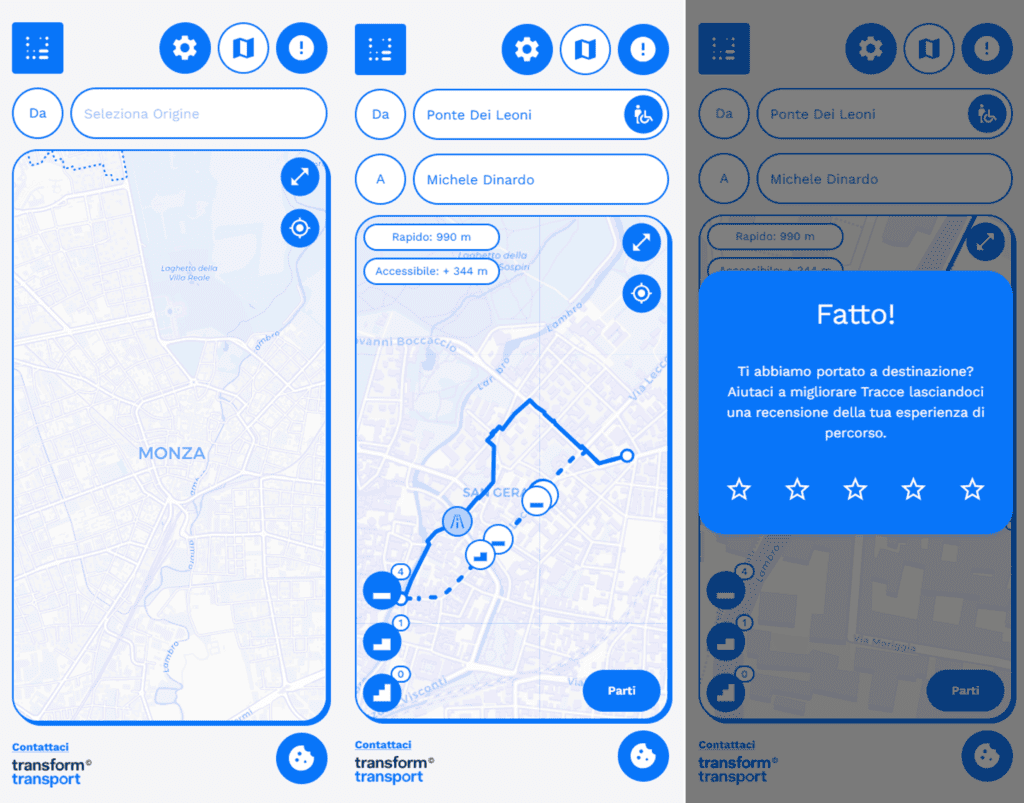
The Reporting functionality allows users to actively contribute to improving the map and the service. The Web App enables users to submit a georeferenced report by selecting a type from a predefined list (e.g. uneven surface, missing ramp, obstacles, illegal parking, etc.) and, if useful, adding a descriptive comment. The reports are collected in structured form and become a “dynamic” information layer, useful for identifying issues not yet mapped, validating existing data, and recording conditions that change over time, supporting a progressive update that is more closely aligned with the reality of urban space.
Conclusions and Future Work
The “Tracce” project demonstrates how the integration of user-centered methodologies, digital tools, and participatory processes can provide concrete support to urban accessibility policies. The adopted approach makes it possible to complement traditional planning with an interpretation more closely aligned with the everyday experiences of people with reduced mobility, translating needs, perceptions, and critical issues into structured data and operational tools.
The combination of multilevel mapping, WebGIS, and Web App provides a dynamic overview of accessibility in the city of Monza, useful both for increasing user autonomy and for guiding administrative decisions toward more targeted, monitorable, and shared interventions. From this perspective, the project represents a replicable and adaptable foundation for other urban contexts, contributing to the promotion of a vision of accessibility as a continuous, participatory process integrated into city governance.
The project provides the Municipality of Monza and Monza Mobilità S.r.l. with data, metrics, and tools useful for the development and implementation of the PEBA. Through the combination of quantitative data and qualitative user experiences, the project supports evidence-based decision-making processes, contributing to the creation of more inclusive, accessible, and welcoming urban spaces for residents and visitors. The Tracce project includes a further phase of data collection and analysis deriving from the use of the Web App. In particular, GPS traces and routes planned through the use of the app, as well as reports collected through user contributions, will be analyzed between February and June 2026 in order to contribute to a progressive update of the multilevel mapping activities carried out during the project.
Acknowledgments
The Tracce project is a collaboration between the Comune di Monza (Mobility, Traffic, and Public Assets Department; Participation, Housing Policies, Youth, Equal Opportunities Department), Monza Mobilità S.r.l., and Fondazione Transform Transport ETS. We thank Iacopo Neri, responsible for the Full-Stack Design and Development. Project activities carried out by Transform Transport from February 2024 to January 2025 were funded by Monza Mobilità S.r.l. (CIG: B84083A5F5). Data collected during the project are processed in compliance with the General Data Protection Regulation (EU GDPR, 2016/679).
We thank the associations and citizens involved in the listening and participatory phases of the project (in alphabetical order: Associazione Auser, Associazione Stefania, Centro civico Libertà e Cederna, Comunità Abbatti le barriere della sezione Monza-Brianza, Cooperativa sociale La Nuova Famiglia, Cooperativa Sociale Nuovo Millennio, Lambro Società Cooperativa Sociale ONLUS, Mondo Accessibile, Rete TikiTaka, Unione Italiana dei Ciechi e degli Ipovedenti ETS, Unione Italiana Lotta alla Distrofia Muscolare, UROBURO Onlus).
References
Dickson-Deane, C., & Chen, H. L. O. (2018). Understanding User Experience. In Encyclopedia of Information Science and Technology, Fourth Edition (pp. 7599-7608). IGI Global. https://doi.org/10.4018/978-1-5225-7598-6.ch117
European Commission. (2021). Union of Equality: Strategy for the Rights of Persons with Disabilities 2021-2030. Retrieved from https://eur-lex.europa.eu/legal-content/EN/TXT/?uri=CELEX%3A52021DC0101
Hara, K., Sun, J., Moore, R., Jacobs, D., & Froehlich, J. (2014). Tohme: Detecting curb ramps in google street view using crowdsourcing, computer vision, and machine learning. In Proceedings of the 27th Annual ACM Symposium on User Interface Software and Technology (pp. 189–204). https://doi.org/10.1145/2642918.2647403
Steels, S. (2015). Key characteristics of age-friendly cities and communities: A review. Cities, 47, 45-52. http://dx.doi.org/10.1016/j.cities.2015.02.004
Systematica and Transform Transport (2025). UX Mobility. https://issuu.com/systematica/docs/ux_mobility
Sze, N. N., & Christensen, K. M. (2017). Access to urban transportation system for individuals with disabilities. IATSS research, 41(2), 66-73. https://doi.org/10.1016/j.iatssr.2017.05.002
United Nations. (2006). Convention on the Rights of Persons with Disabilities. Retrieved from: https://www.un.org/disabilities/documents/convention/convoptprot-e.pdf
Regione Lombardia. (2021). Linee guida per la redazione dei PEBA – Piani per l’accessibilità e l’usabilità dell’ambiente costruito, inclusione sociale e benessere ambientale. Available at: https://www.regione.lombardia.it/wps/portal/istituzionale/HP/istituzione/Giunta/sedute-delibere-giunta-regionale/DettaglioDelibere/delibera-5555-legislatura-11?utm_source=chatgpt.com