
The scientific research project “STEP UP – Walkability for Women in Milan”, submitted under the call for proposals “INEQUALITIES RESEARCH – Generating new knowledge to reduce inequalities” and awarded by Fondazione Cariplo (Grant No. 2022-1643), focuses on the level of walkability for women based on the perceived safety at night, in the city of Milan. Transform Transport coordinated STEP UP from March 2023 to the end of February 2024 in collaboration with TeMA Lab – Università degli Studi di Napoli Federico II, Sex and the City, and Walk21 Foundation.
Gender Inclusion in Transport Planning
Advanced urban and transport planning activities are shifting towards sustainable urban mobility solutions and walkability, referring to how friendly the urban environment is for walking in terms of proximity service availability, street connectivity, the comfort of public spaces, and road safety.
Although traditional approaches tend to focus only on the spatial dimension of cities, individual characteristics of users are found to have a significant impact on the perceived level of walkability of streets and public spaces (e.g., demographics, travel purposes, mobility preferences, etc.). In particular, the current measures in place do not sufficiently consider population groups in vulnerable situations (i.e. SDG 11.2-Sustainable Transport for All), including women.
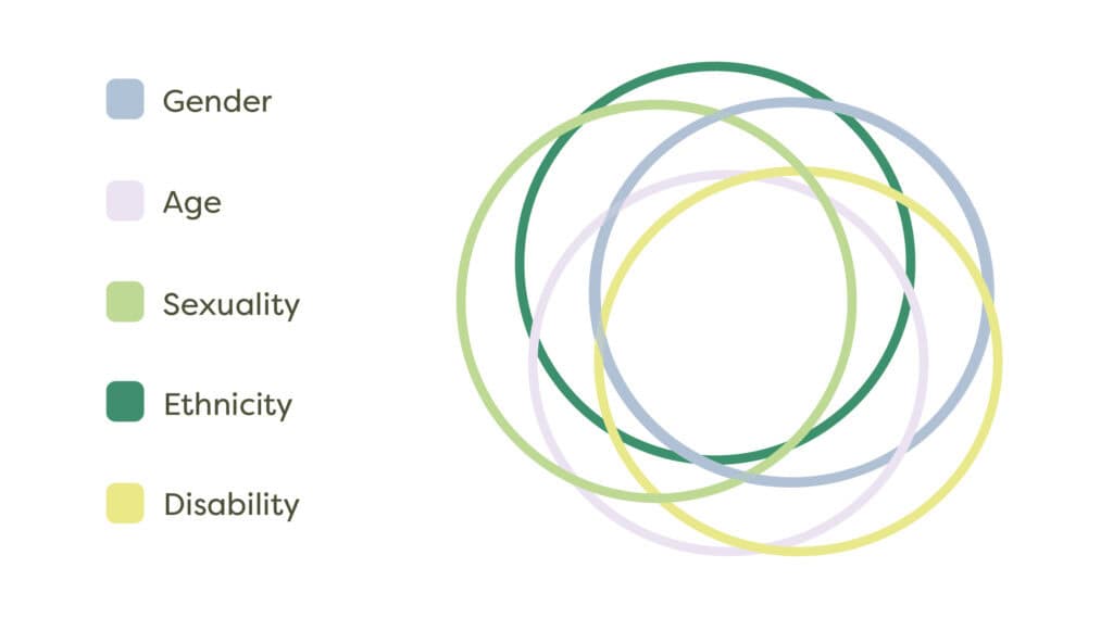
Women experience the city differently than men, in part because they are more concerned about security issues related to aggression and harassment. These concerns take the form of precautionary or avoidant behaviors due to fear of violence, perception of risk, and a sense of vulnerability, which are major mobility obstacles especially during the nighttime. The STEP UP project aims to shed light on the relevant factors that influence women’s perceptions of safety while walking in the city of Milan at night, particularly focusing on factors related to the urban environment such as spatial features, city use (behavioral features) and hotspots, and factors relating to the subject’s identity, such as gender identity, age and economic situation (see Figure 1).
Scope and Methodology of the Research
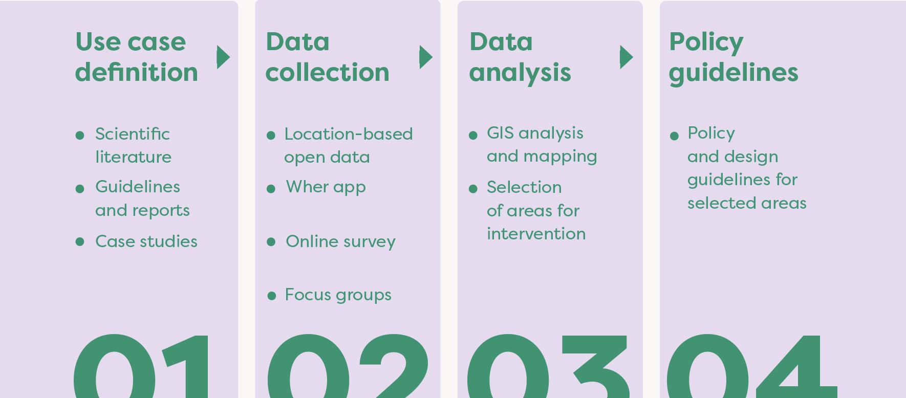
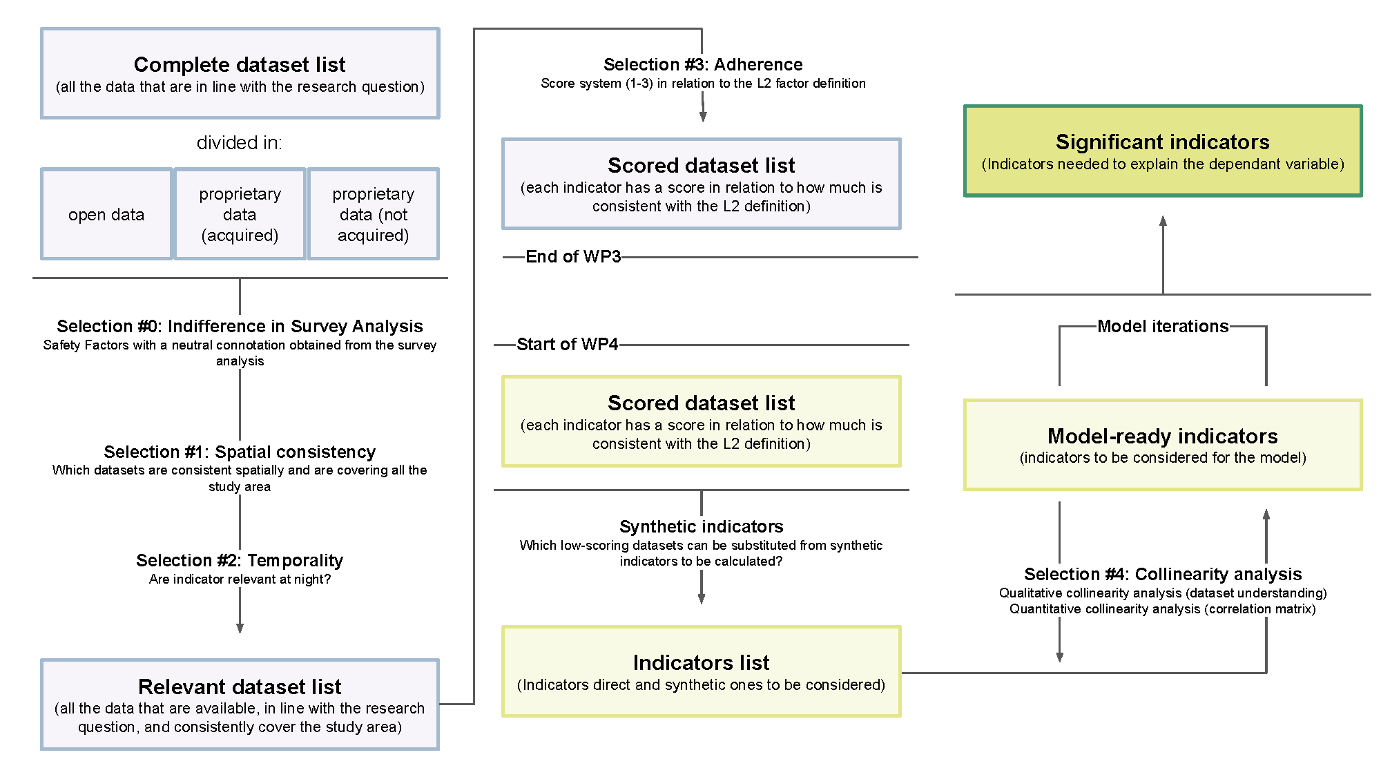
Taking these challenges into consideration, STEP UP aims to assess the level of walkability for women focusing on the case study of Milan, Italy, in particular on the factor influencing the perception of safety while walking (see Figure 2). First, a thematic literature review has been conducted on the most relevant scientific contributions and policy guidelines about the topic. The results of the literature review were then exploited to develop two streams of analysis: (a) a survey and focus group discussions in select Milan neighborhoods aimed to collect further information from residents and city users to validate the results of the literature review and expand on these; and (b) a GIS mapping analysis to explore how these results play out across space. To build the GIS model, the literature review outputs were used to select a series of relevant geolocated datasets, which were retrieved, sorted, and filtered from open data repositories and geoportals, in order to study the relationship between factors influencing perception of safety and women’s reported perceptions of safety. Data regarding women’s reported perceptions of safety while walking were collected through ‘Wher’ – a safety reporting navigation app operated by Walk21 Foundation. The data was then analyzed through GIS to design a multi-layered map of Milan focusing on improvable areas based on the most relevant safety factors as determined by a spatial regression model.
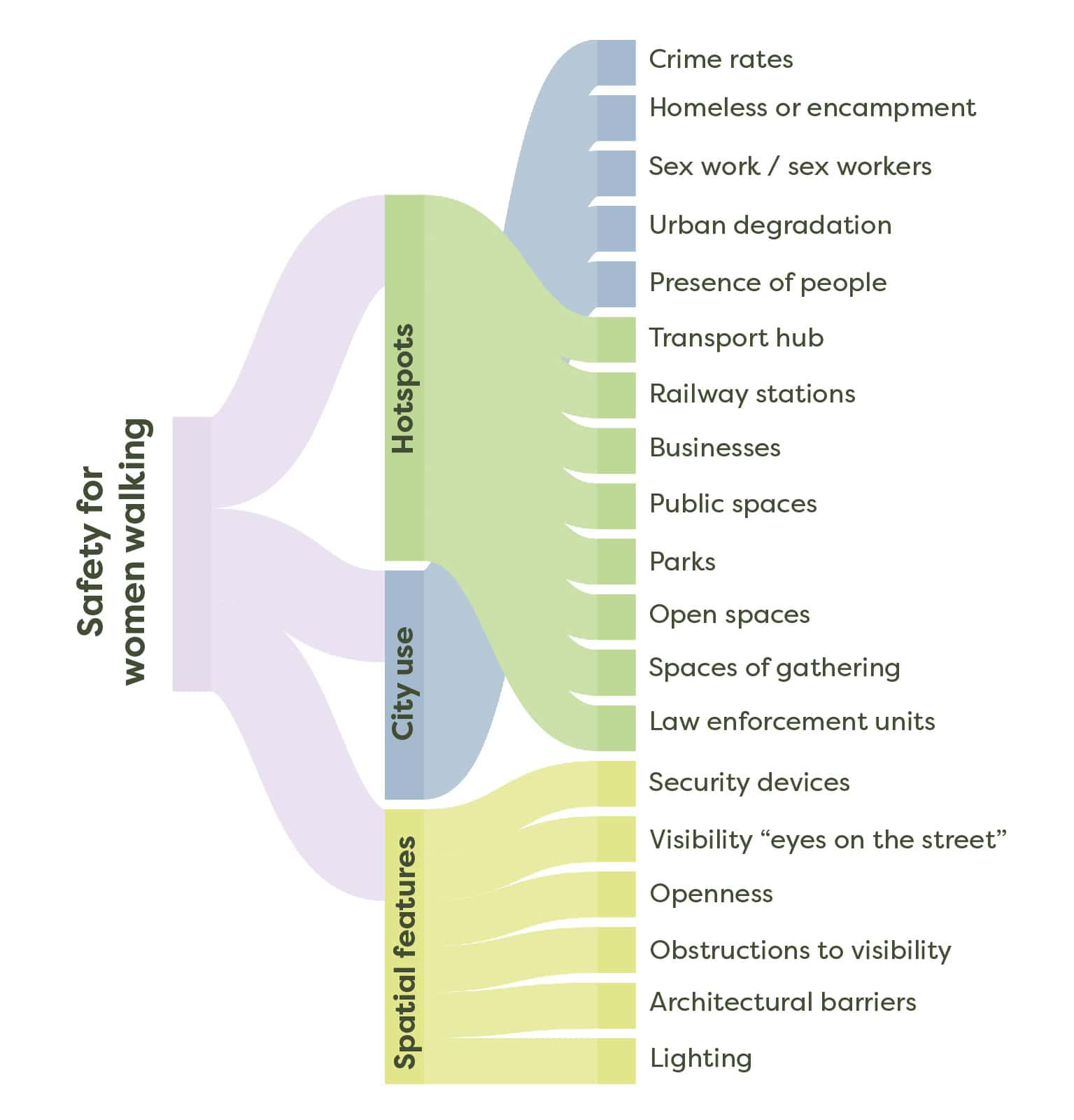
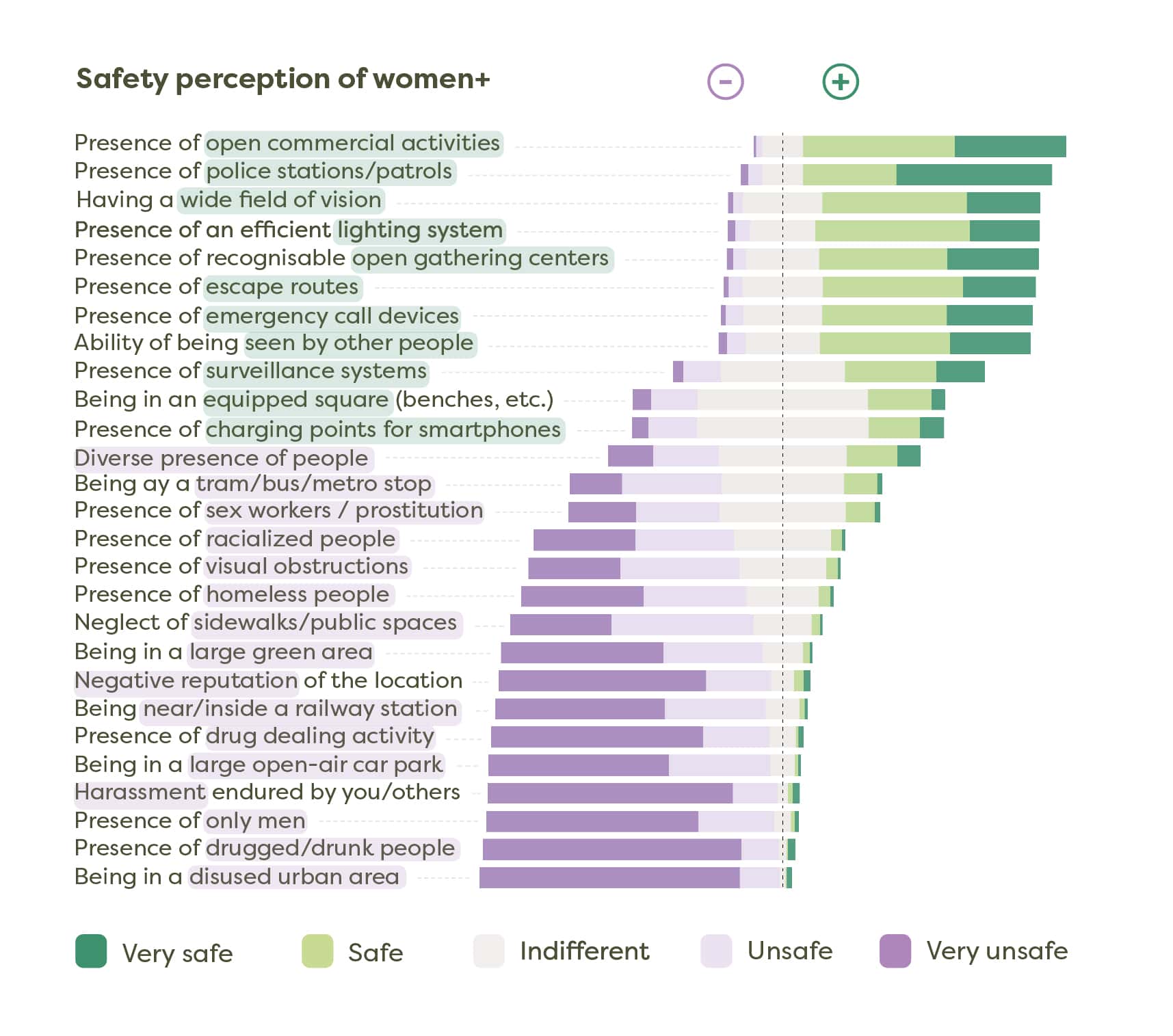
In order to identify the main factors influencing perceptions of safety while walking for women, a scoping review was conducted on some of the most relevant scientific contributions and policy guidelines about the topic. This resulted in the establishment of three main Safety Factors – Level 1 (SF_L1): (i) Spatial Features (space characteristics/ morphological features); (ii) City Use (traces of behavior and presence of other city users); and (iii) Hotspots (safe havens and no-go areas); further resulting in 19 sub-factors or Safety Factors – Level 2 (SF_L2) as show in the chart below (see Figure 3). These safety factors form the basis of analysis, explored both qualitatively in the form of a survey to verify and weigh their relevance by actual city users, as well as quantitatively through a GIS statistical model aimed to study the relationship between measurable safety factors and georeferenced safety votes collected through the Wher app across the city. A list of demographic features were also studied through an extensive survey targeting users of Milan, in order to understand the intersectional diversity of perceptions of safety based on various elements of a user’s identity as outlined in the chart below.
Project Results
Results of the project are varied following the multimodal methodological approach. Below are some of the salient features of this multimodal analysis.
The online survey, counting over 1800 responses, gave insights into the variability of safety perception between genders and across different socioeconomic profiles of female respondents. Between the survey questions and the user comments from the Wher app data, we have a wealth of qualitative information about what makes women and gender minorities feel safe or unsafe while walking in the city. Here we start to see more detailed information about how women feel about each individual safety factor under study, as well as additional factors that popped up in open-ended text responses. Through Sentiment Analysis, some key insights can be drawn about the diversity of safety perception across different people and different places. The chart below shows the distribution of the significance and value of different safety factors among women and gender minorities who responded to the survey (see Figure 4).
Focus groups enriched the research in a qualitative way, making it a collective and personal narrative: they allowed for the creation of a free space in which to listen to the direct testimonies of female citizens of various ages and backgrounds. The focus groups delved into three selected neighborhoods – which emerged from the overlapping of data from the Wher app and the open answers to the survey with low safety perception scores (Central Station and Loreto). or, on the contrary, with high perception votes (Sarpi). Focus group discussions were organized in each of the three neighborhoods, using community mapping methods as a way to elaborate on views of users with a good familiarity of the selected areas. The focus group sessions were designed as structured discussions between members of the Consortium and a selected group of six participants in each of the 3 selected neighborhoods.
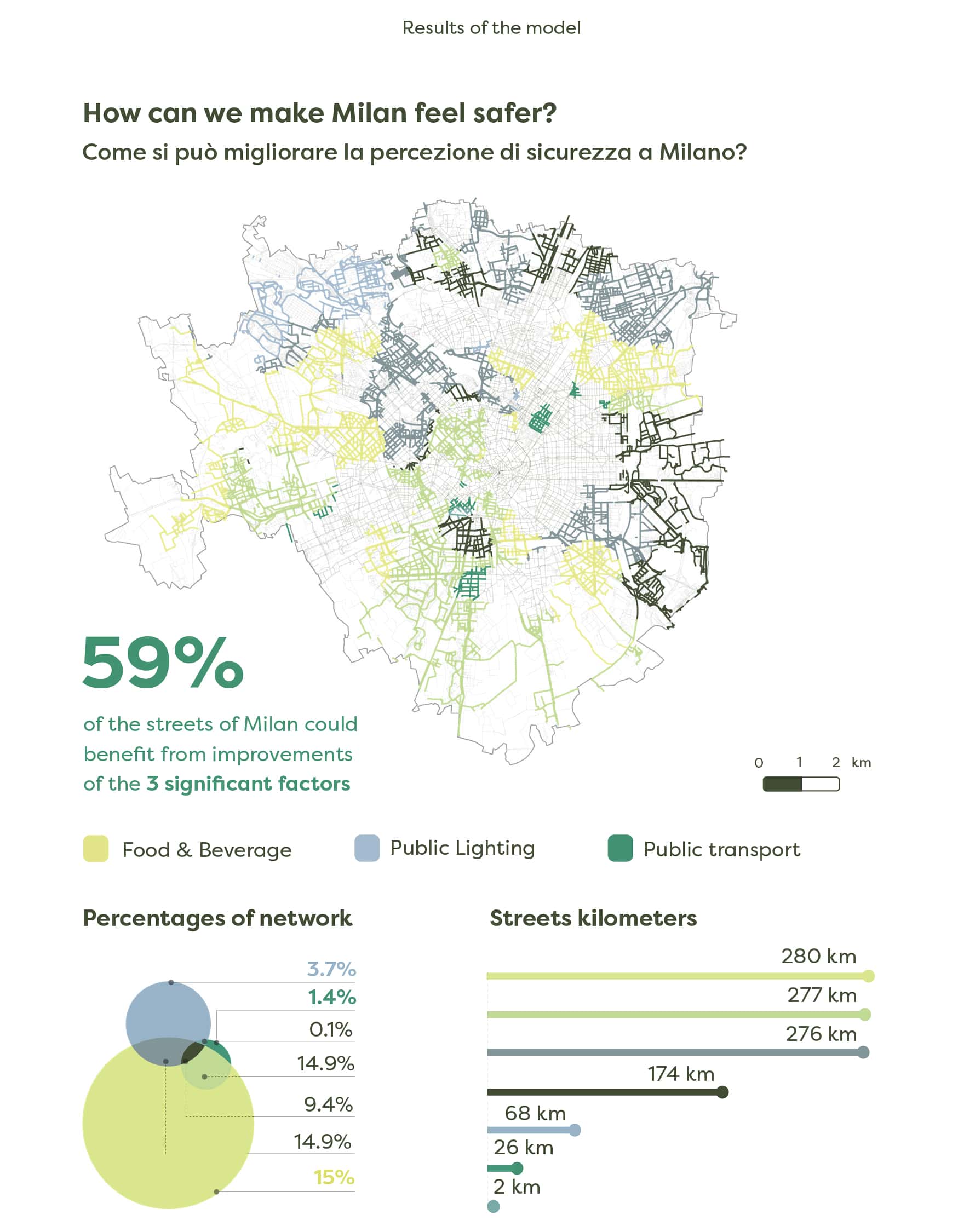
The project results help to identify challenging areas in the city of Milan, which could benefit from further investigation and direct intervention to enhance safety perception among women. The aim of the project, however, is not to pinpoint universally perceived unsafe areas but rather focus on a narrative of safety built at the intersection of qualitative and quantitative approaches, capable of tackling multiple dimensions of a complex phenomenon such as safety perception through direct urban interventions. In particular, the quantitative side of the process stemmed from the identification of city characteristics deemed able to induce a higher or lower sense of safety, to ultimately assess these characteristics in a spatial regression model aimed at predicting the same information gathered from the crowdsourced scores acquired from Wher App. Through this analysis, we are able to categorize areas of the city based on their relation with three indicators deemed significant and reliable by the statistical model: (i) public lighting (presence and maintenance of adequate lighting systems); (ii) frequency of street-level public transport services at night (trams and buses); and (iii) presence of food and drinks destinations (open businesses at night).
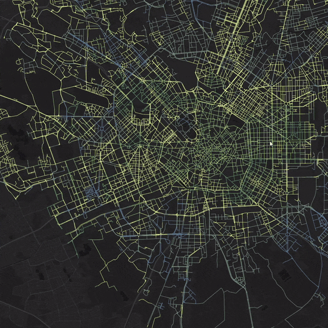
Finally, the resulting eight indicators were used to calibrate a Geographically Weighted Regression (GWR) Model, which emerged reliable with the three above-mentioned indicators. This enabled a further analysis to determine areas of the city that could benefit from improvements with respect to these three indicators, and which is defined as any area in which the value of the predicted safety score is less than 2.2 (where 1 is negative; 2 is neutral and 3 is positive), and with a local R2 higher than 0.7. This selection is meant to include areas that could benefit from improvement according to the model and that are reliable according to the model diagnostics, and include about 60% of the streets of Milan, shown in the map below (see Figure 6). In short, the map highlights areas of the city where the improvement of the conditions of each indicator would yield a positive outcome on the safety perception of women and gender minorities while walking in the city at night, which in turn are related to the following factors:
- Street lighting systems: the design of streets and public spaces should include the presence and maintenance of adequate lighting systems in order to guarantee an higher awareness of one’s surroundings and consequently a higher perception of safety of women+ while walking at night time;
- Bars and restaurants: open businesses at night time attract the presence of people, which increases the perception of safety of women+ related to the possibility of receiving social support, albeit from strangers, rather than a feeling of desolation and isolation;
- Public transports: the enhancement of public transport at night time will make bus and tram stops into more attractive elements of the urban environment, thus drawing more attention and resulting as more recognizable hubs.
STEP UP Additional Resources
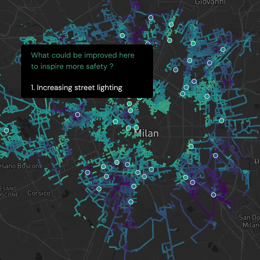
STEP UP – data storytelling: Designed by Modality, this webgis platform provides an interactive mode to investigate data results of the STEP UP research project focusing on the spatial diversity of the factors that influence women’s perception of safety.
STEP UP – Safety Index Map: The map shows the perceived safety during the night estimated through a Geographically Weighted Regression Model. Explore the map interactively by scores and districts.


