
Milan aims to make cycling a more prominent form of transportation. This investigation was undertaken to better understand the state of cycling in Milan, analyzing the current and planned cycling infrastructure against vehicular and cycling flows and accidents.
Introduction
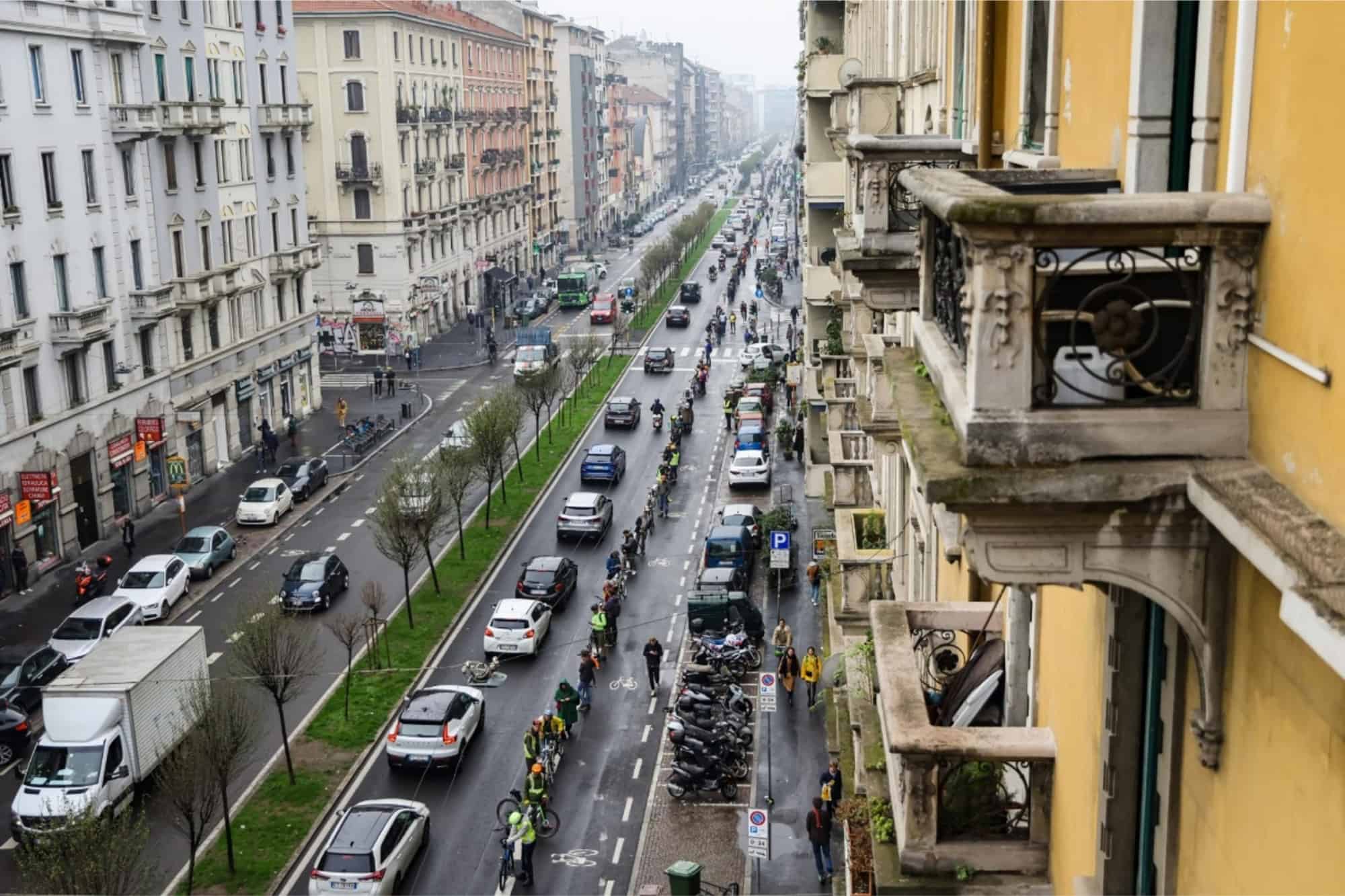
Cycling is one of the main forms of sustainable and active transportation that provides health, environmental, and socio-economic benefits. It is a cost-efficient, low cost and low carbon form of transportation that is key to mitigating climate change, reducing traffic congestion, and improving urban accessibility (Adriazola-Steil et al., 2021; Yanocha and Mawdsley, 2022). Cycling also promotes active lifestyles that can reduce the risk of noncommunicable diseases and overall mortality (WHO Regional Office for Europe, 2022). The COVID-19 pandemic spurred a renewed interest in cycling across Europe and Milan, Italy, was no exception. In Milan, 86 km of new cycle lanes were built between 2020 and 2022 (Agenzia Mobilità Ambiente Territorio, 2023; Christidis et al., 2023). New cycling infrastructure has been accompanied by an increase in cyclists around the city and a subsequent increase in accidents, sparking debates and citizen protests around safety issues for cyclists (see Figure 1).
Milan has committed to further expanding and improving the quality of the cycle lane network, increasing the number of trips taken by bicycle, and to make cycling safer to promote more “livable and sustainable” neighborhoods (Agenzia Mobilità Ambiente Territorio, 2023). This aligns with the broader EU commitments to promote cycling as a main form of transportation, as highlighted by the recent adoption of the EU Declaration on Cycling (European Commission, 2023), which declares “improving the quality, quantity, continuity and attractiveness of cycling infrastructure is essential to promote greater cycling use.”
In this framework, the aim of this investigation is to support the transformation of Milan into a cycling city, help residents achieve their Right to Cycle and to promote an evidence-based approach for the urban development of the city. The research was undertaken to better understand where people cycle the most, where it is dangerous to cycle, and which streets have the greatest conflict between cars and bicycles.
Enabling Data and Methodology
This study relies on five key geo-spatial and statistical datasets (see Table 1).
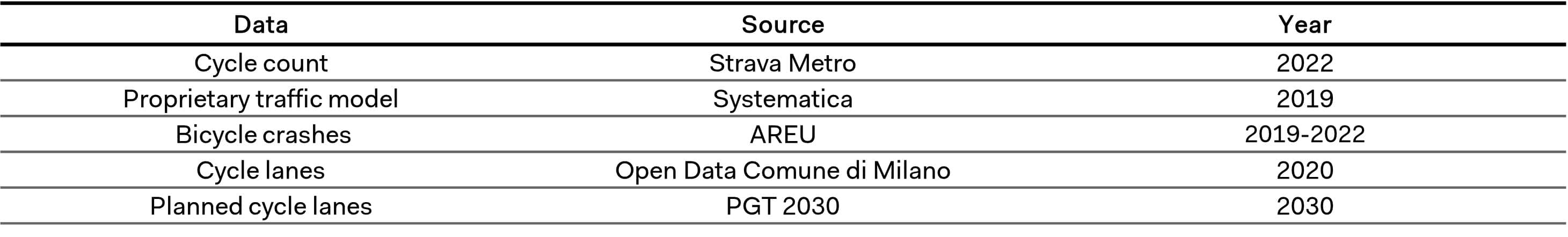
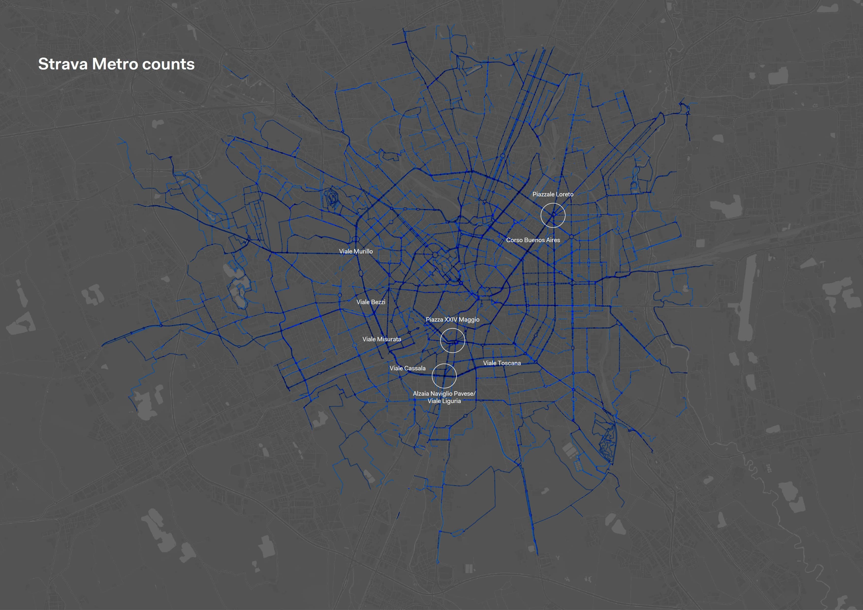
Cycle counts are collected through Strava Metro, a GPS dataset of the cycle trajectories of its users, that quantifies yearly cycle volumes on street segments (see Figure 2). Vehicular counts are obtained from a proprietary traffic model of Systematica (2019) that estimates the peak hourly flows of cars and heavy vehicles on street segments. Geo-localized bicycle crashes are sourced from the AREU-Agenzia Regionale Emergenza Urgenza, and include all accidents that involved a cyclist between 2019 and 2022, classified by crash outcome severity.
The methodology for this research is structured in three phases. A first diagnostic phase explores the changes in cycling volumes and accidents between 2019 and 2022; both showed a constant increase. Then, the study aims to locate which streets have the greatest concurrent cars and bicycles flows, calculating a Conflict Index that compares Strava Metro cycle counts with vehicular flows. The goal is to identify critical areas for cyclists’ safety. Milan is first divided into hexagonal areas and the highest cycle counts and vehicular flows spatially intersecting each area are associated to it. Then, a bivariate index is built on the quantiles of the two datasets, identifying co-presence intensity between the two modes in Milan. Then, the Conflict Index is compared with AREU’s cycling accidents that occurred in Milan in the same timeframe. Last, the validated Conflict Index is analyzed with respect to the state of the existing cycle infrastructure and the planned infrastructure, to define the relation between the safety and infrastructure in Milan.
Results
Where do people cycle in Milan
Milan’s current cycle lane network covers 11% of the total road network, which includes 108.5 km of dedicated cycle lanes. The Strava Metro data indicates that the greatest levels of cycling occur on the cycle paths alongside the Alzaia Naviglio Grande, the Alzaia Naviglio Pavese, and the Naviglio Martesana. Among urban corridors, the outer ring road of Milan (including Viale Murillo, Viale Cassala and Viale Toscana) and Corso Buenos Aires stand out for the high cycling volumes.
Bicycle crashes in Milan
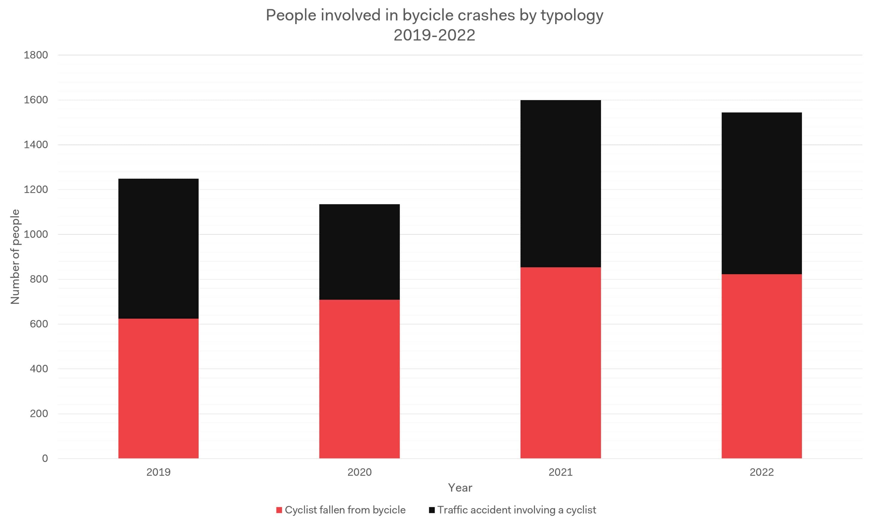
There were 6449 bicycle crashes in Milan between 2019 and 2022, that involved 6795 people, although this is likely an underestimation as the data only includes crashes for which the emergency services were called. Most crashes (67%) did not result in a severe injury (green hospitalization code) and less than 1 percent (0.7%) of crashes led to a severe injury. Chart 1 shows the increase of accidents involving cyclists between 2019 and 2022, divided by accident typology (i.e., cyclist fallen from bicycle and traffic accident involving a cyclist).
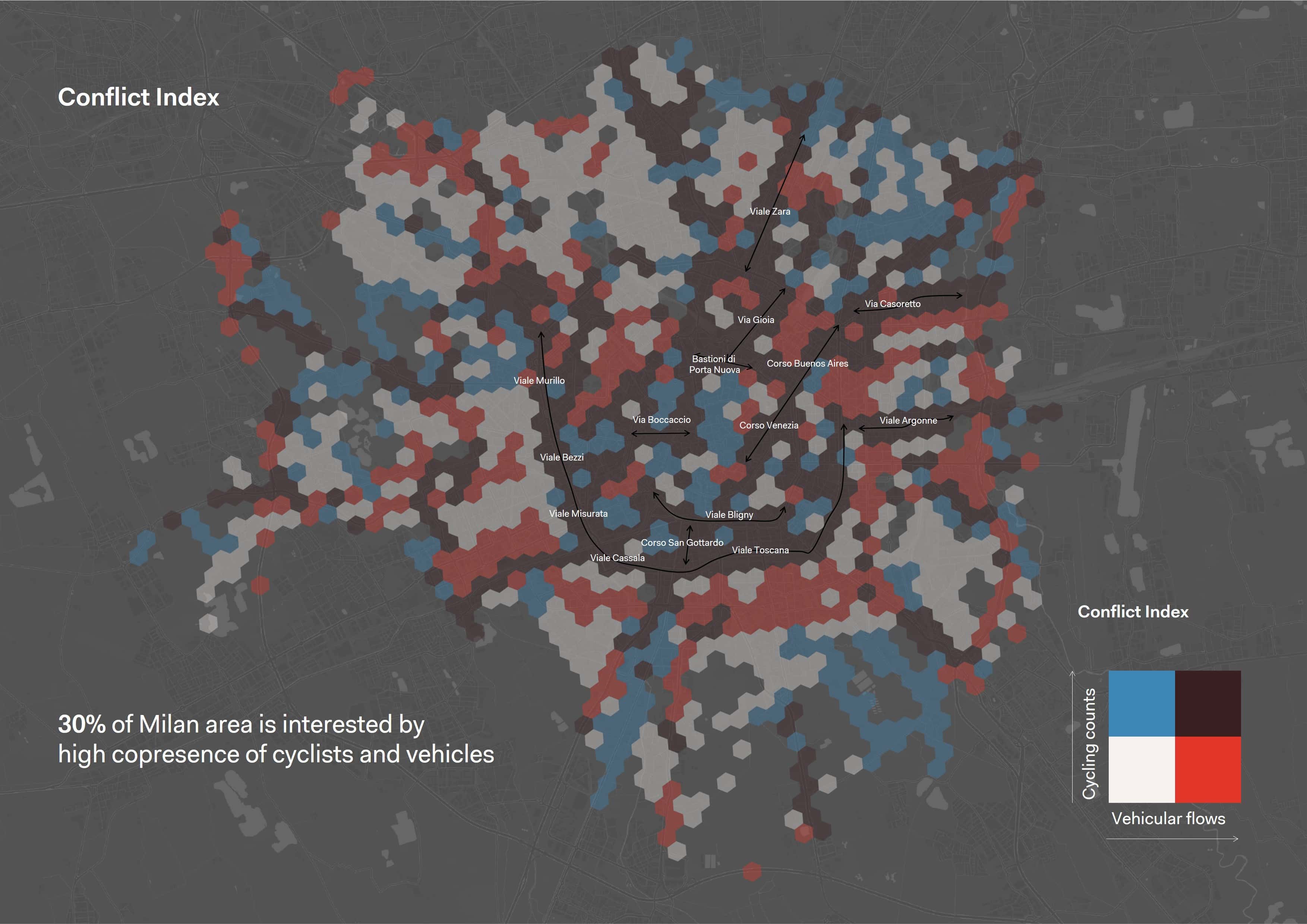
Conflict Index
The Conflict Index map locates streets that have the greatest concurrent car and bicycle flows, comparing Strava Metro cycle counts with vehicular flows. The map identifies areas with high co-presence of cyclists and vehicles, which revolves around the south-west stretch of the outer ring road of Milan (e.g., Viale Murillo, Viale Misurata, Viale Cassala, Viale Toscana, etc,) and the main axes entering the city center (e.g., Viale Zara, Corso Buenos Aires, Viale Argonne, etc.). This high-conflict area covers roughly 30% of the municipality of Milan (see Figure 3).
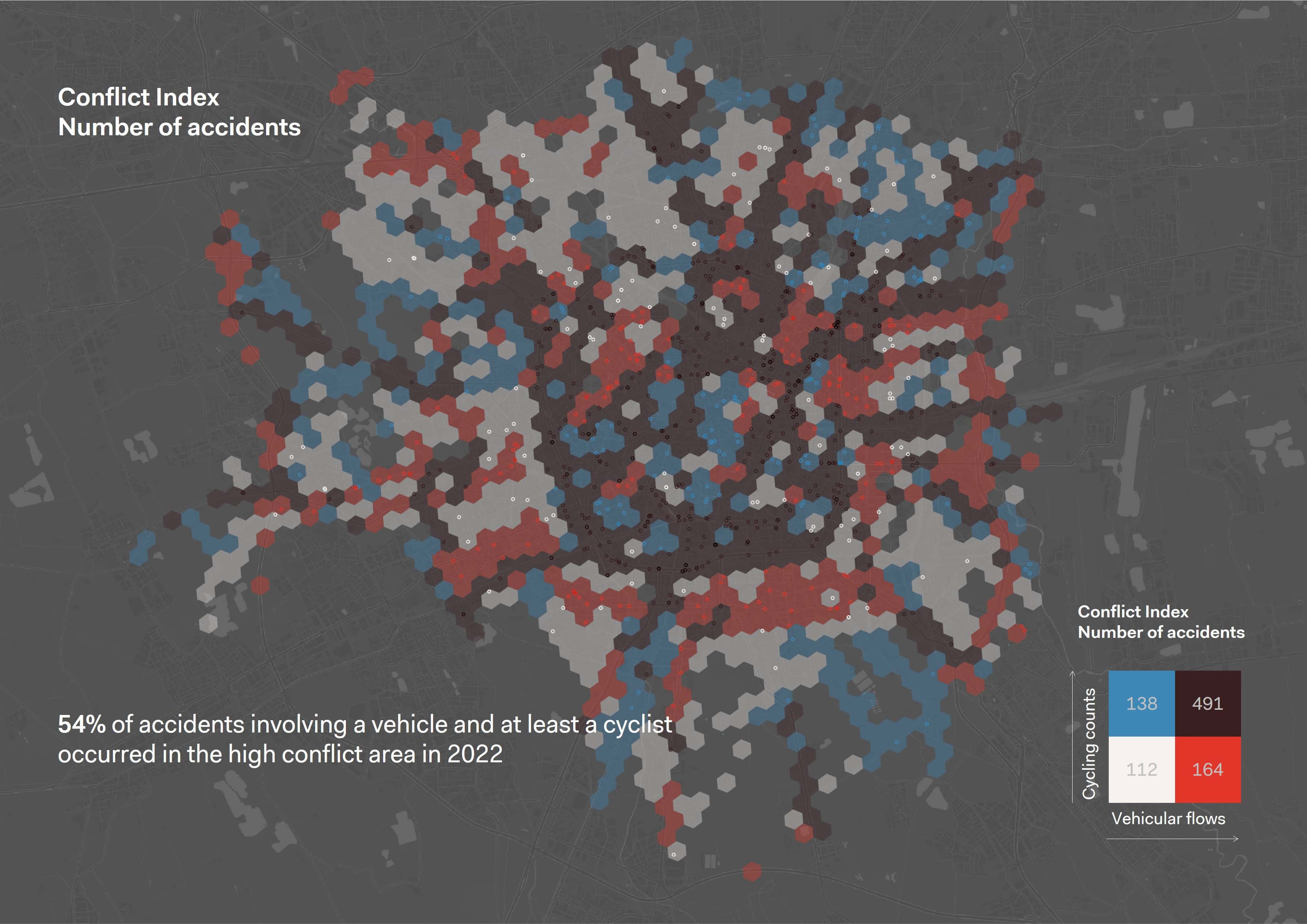
The Conflict Index map is intersected with the geo-referenced accidents dataset. It highlights that roughly 54% (80% percentile) of all accidents involving at least one cyclist and one vehicle took place in a high-conflict area in 2022 (see Figure 4).
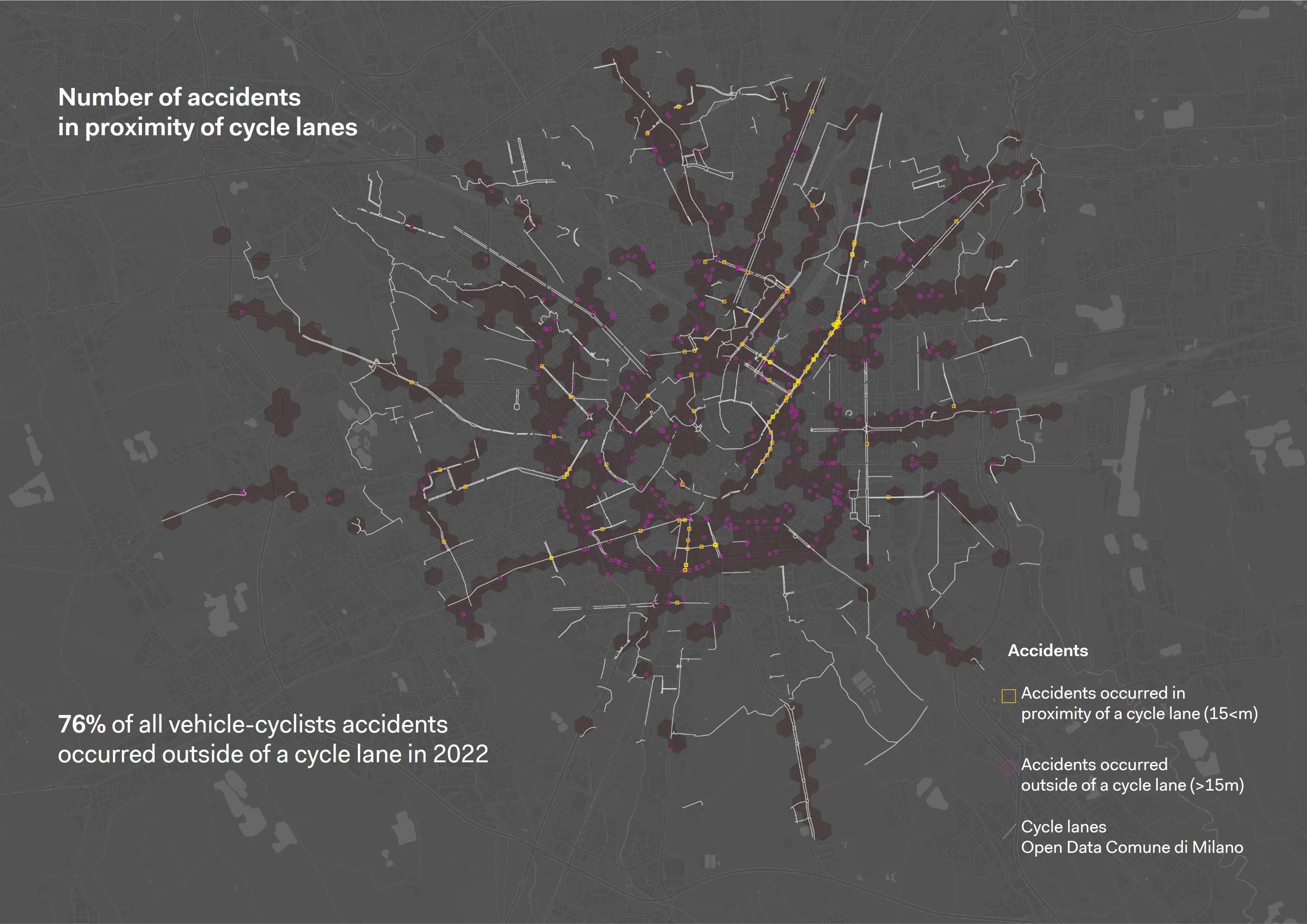
Among these accidents, only 24% occur in the proximity of a cycle lane (defined as a distance <15m), while 76% of all vehicle-cyclists accidents occurred outside of the existing cycling infrastructure. This calls attention to the need for continued development of the cycling infrastructure to improve cyclists’ safety (see Figure 5).
Discussion
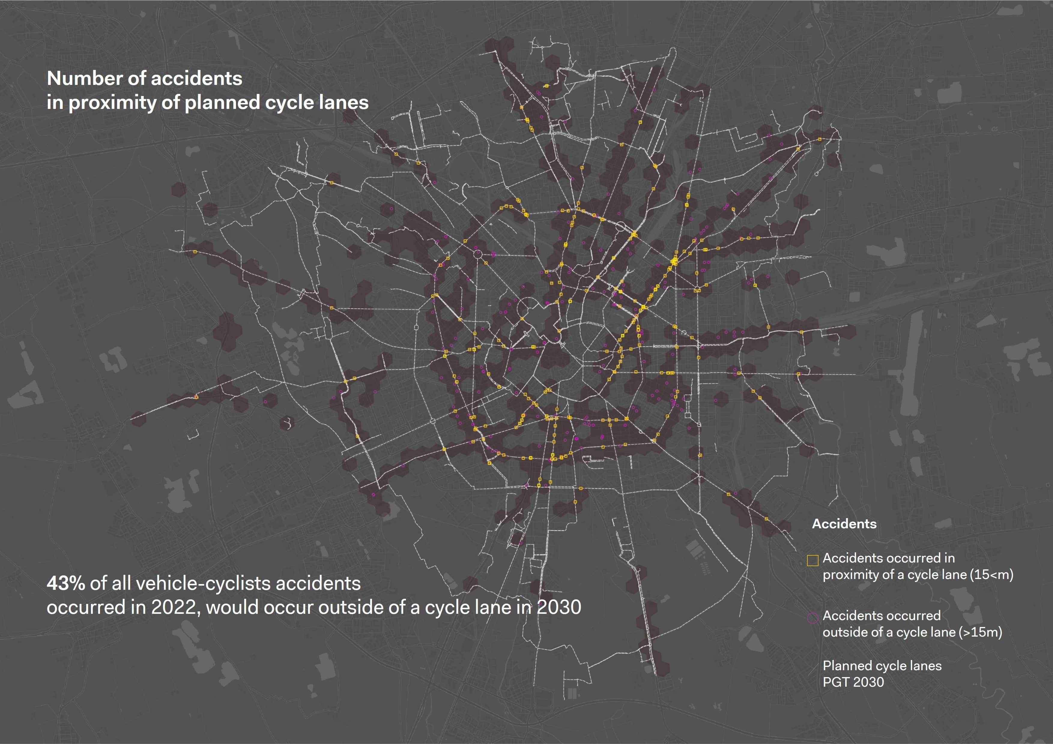
The PGT-Piano di Governo del Territorio 2030 developed by the Municipality of Milan envisages a great increase in the cycle infrastructure in 2030 that covers most of the core road network of the city and connects today’s often fragmented cycle lanes. However, a more capillary development of the cycle infrastructure should be considered as the Conflict Map shows that many cyclist-vehicle accidents occurred on roads outside the planned cycling infrastructure changes (see Figure 6).
Conclusions and Future Works
In October of 2023, the European Commission adopted the EU Declaration on Cycling. One of its guiding principles is “improving the quality, quantity, continuity and attractiveness of cycling infrastructure is essential to promote greater cycling use”. Milan is moving towards this through policy instruments and programs, such as its 2018 Sustainable Urban Mobility Plan, the 2020 Open Streets Strategy for the COVID-19 emergency, and the “Cambio” Bicycle Plan of the Metropolitan City of Milan. Moreover, in 2023, Milan was one of ten cities worldwide selected for the BICI program launched by the GDCI-Global Designing Cities Initiative to implement innovative projects for cycling infrastructure. Milan’s winning bid is a project to connect 40 schools via a cycle route/ network. Milan can expand on this momentum and helps its residents achieve their Right to Cycle by continuing to build and connect its cycling network.
Acknowledgments
We thank Simone Fukuda for her contribution to this research. We thank AREU (Agenzia Regionale Emergenza Urgenza) for their fruitful collaboration and for sharing data. The analyzed data were treated according to the GDPR-General Data Protection Regulation (EU, 2016/679). This research received no specific grant from any funding agency in the public, commercial, or not-for-profit sectors.
References
Adriazola-Steil, C., Ohlund, H., El-Samra, S., Targa, F., & Zayas, G. (2021). Investing for Momentum in Active Mobility. In Transportation Decarbonization Investment Series (Issue October). https://doi.org/10.1596/36617
Agenzia Mobilità Ambiente Territorio (2023). Report della mobilità Milano 2022. https://datashare.amat-mi.it/index.php/s/PgnBD2Kw2zJBK97
Christidis, P., Vega Gonzalo, M., Ulpiani, G., & Vetters, N. (2023). Post-pandemic trends in urban mobility (Issue KJ-NA-31-551-EN-N). Publications Office of the European Union. https://doi.org/10.2760/627403
European Commission (2023). European Declaration on Cycling. https://transport.ec.europa.eu/document/download/60033b3b-0652-495c-add3-ffea2388ff81_en?filename=European_Declaration_on_Cycling_text.pdf
Yanocha, D. and Mawdsley, S. (2022). Making the Economic Case for Cycling. Institute for Transportation & Development Policy. https://www.itdp.org/wp-content/uploads/2022/06/Making-the-Economic-Case-for-Cycling_6-13-22.pdf
WHO Regional Office for Europe. (2022). Walking and cycling: latest evidence to support policy-making and practice. World Health Organization. https://www.who.int/europe/publications/i/item/9789289057882