

Monitoring is a structural component of tactical urbanism rather than merely an ex-post evaluation. Temporary, reversible interventions on roads and plazas can serve as urban planning tools when supported by data and participatory processes. Monitoring integrates quantitative and qualitative analyses and should address five phases: diagnosis, baseline, implementation, evaluation, and transition to permanence. Drawing on Transform Transport’s case studies in Bologna, relying on GIS accessibility mapping, video analysis and TomTom data, the article highlights three key requirements: selecting context-aligned indicators, evaluating multi-scale impacts, and engaging citizens to interpret spatial uses and conflicts, thereby enabling informed decision-making.
From Tactical Urbanism to Informed Public Decision-Making
Tactical urbanism is an experimental methodology capable of anticipating structural spatial transformations, demonstrating the effects of design choices, and structuring participatory processes around public space. Within this framework, monitoring serves as essential decision-making infrastructure rather than an ex-post procedural step. Monitoring produces actionable knowledge that guides policy, highlights criticalities, reinforces initial objectives, and supports institutional learning, transforming temporary actions into evidence-based policy choices.
Tactical urbanism encompasses rapid, reversible, low-cost urban transformations focused on experimentation. As defined by Lydon and Garcia (2015), it represents short-term action for long-term change. Unlike guerrilla urbanism or social streets, tactical urbanism does not replace formal statutory planning or negate permanent design; rather, it establishes the preconditions for public authorities to observe, learn, and adapt. Global guidance from NACTO and GDCI (GDCI, 2020; GDCI, 2022), along with Italian initiatives like Milan’s Piazze Aperte and Bologna’s school plazas, demonstrates how tactical interventions can integrate into broader urban policy. Without robust evaluation, tactical interventions risk remaining isolated symbolic gestures or being judged on subjective perceptions.
Monitoring distinguishes intended design goals from actual spatial impacts. Interventions intended to improve pedestrian safety may inadvertently disrupt cycling networks, foster social exclusion, shift traffic to adjacent residential streets, or generate nocturnal nuisances. Structured monitoring replaces public controversy and political friction with a shared empirical baseline. Tactical urbanism achieves maximum utility when embedded within an iterative learning sequence: diagnosis, pilot implementation, systematic observation, design adaptation, consolidation, and scalable replication. This aligns with foundational public space research by Whyte (1980), Appleyard (1981), and Gehl (2013), emphasizing the evaluation of human behaviors, social relationships, and spatial perceptions alongside physical morphology.
Learning Sequence, Multi-Scalar Framework and Tools
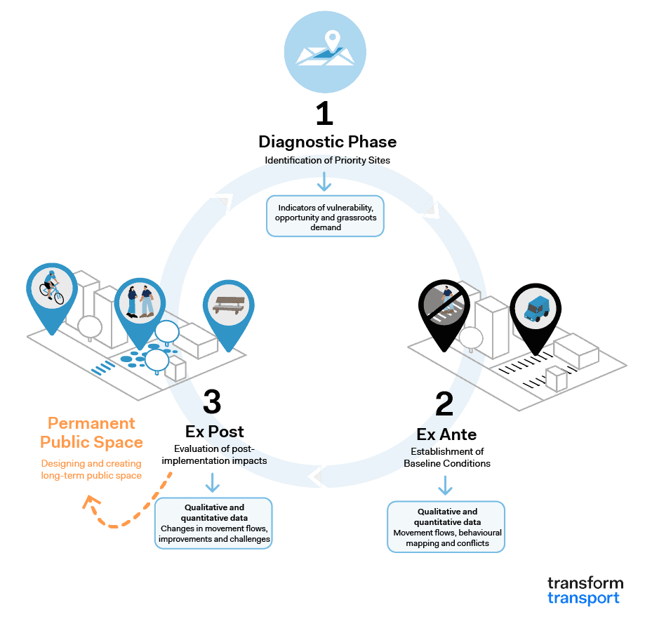
Effective monitoring accompanies the entire lifecycle of an intervention across three distinct phases:
- Diagnostic Phase: operates at a macro city scale to identify priority sites using multi-criteria mapping of proximity services, public space deficits, socio-economic conditions, traffic safety, and population density, supported by public engagement;
- Ex-Ante Phase: establishes baseline conditions at a micro/meso scale by gathering quantitative metrics (traffic flows, parking turnover, pedestrian dwell times) and qualitative data (spontaneous behaviors, safety perceptions, place attachment, participatory digital mapping);
- Ex-Post Phase: evaluates post-implementation impacts after several weeks. Combining quantitative and qualitative metrics, it identifies operational friction points to inform permanent architectural redesigns based on observed usage.
Monitoring operates across three interconnected spatial scales: Macro (evaluating city-wide service distribution and proximity mapping; Meso (assessing neighborhood-scale impacts, spillover traffic effects, and perceptual quality); and Micro (analyzing street-level interactions, seating behaviors, microclimates, and user trajectories).
An effective monitoring framework addresses four key dimensions:
- Sustainable Mobility: Focuses on functional movement, modal shifts, traffic safety, desire lines, and network continuity;
- Social Quality and Inclusion: Evaluates public space diversity, co-presence, and intersectional accessibility (Crenshaw 1989);
- Environmental Performance: Tracks air quality, noise levels, thermal comfort, surface permeability, and urban heat island mitigation;
- Socio-Economic Dynamics: Monitors local commercial vitality, property value fluctuations, tourism pressure, gentrification risks, and nocturnal activity.
Quantitative tools (Kandt & Batty, 2021) from traffic engineering, geomatics, and spatial planning include computer vision trajectory analysis, GPS and TomTom floating car data, air quality sensors, agent-based simulations, Space Syntax accessibility analysis, and GIS thermal comfort mapping. These metrics establish baselines and measure multi-scale flow variations while adhering to data privacy protocols.
Qualitative tools (Gifford, 2016) derived from environmental psychology and participatory design include field observations, interviews, focus groups, behavioral mapping, physical trace analysis, and crowdsourced mobile mapping. These methods capture cognitive, sensory, and affective user experiences beyond pure functional efficiency.
Lessons Learned from the Case Study in Bologna
Research conducted by Transform Transport in Bologna (from December 2020 to August 2023) with the Municipality of Bologna and Fondazione IU Rusconi Ghigi illustrates multi-scalar monitoring centered on child mobility and school zones.
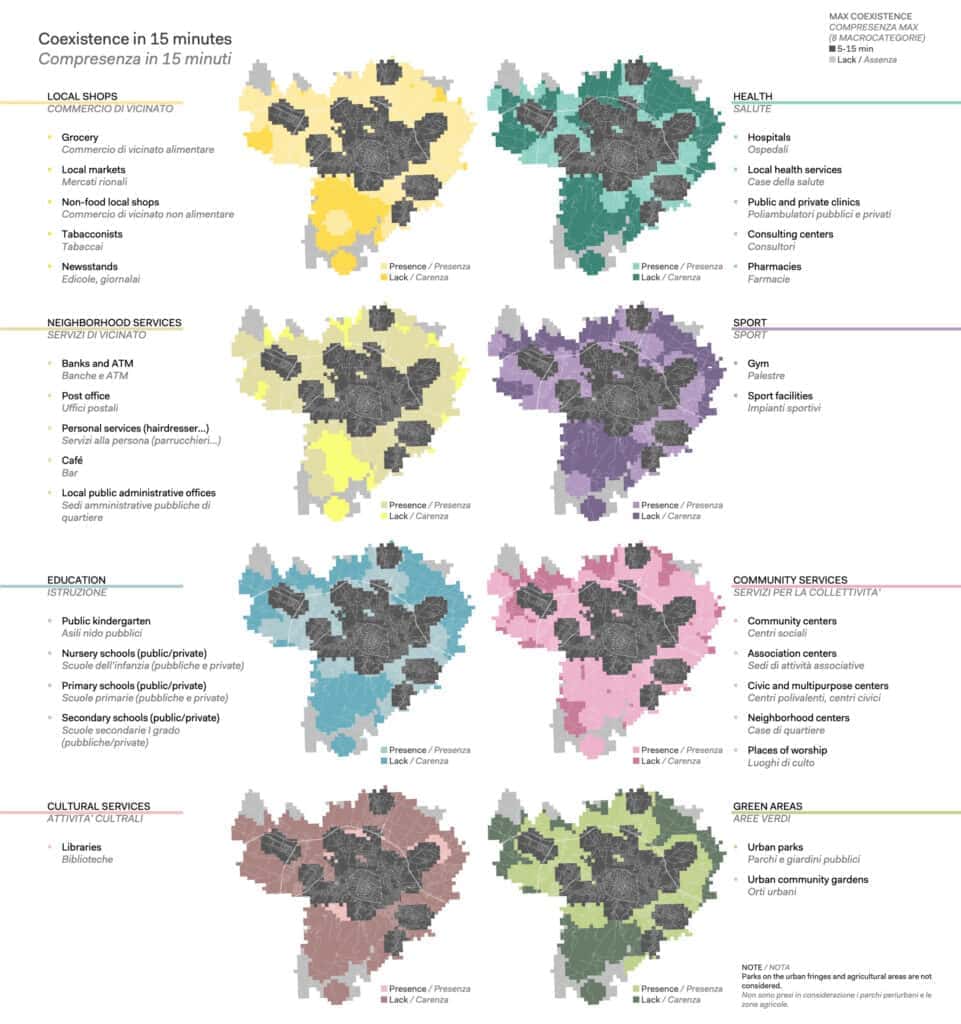
- Macro Scale (see Figure 2): GIS analyses evaluated proximity service accessibility for children aged 5–13 (Abdelfattah et al., 2021), directly informing Bologna’s 2021 General Urban Plan (PUG). Subsequent research analyzed child walkability and Space Syntax spatial integration around target schools in the Bolognina district (Gorrini et al., 2023).
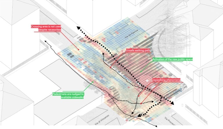
- Micro Scale (see Figure 3): Following the March 2022 implementation of the Via Procaccini school plaza, automated computer vision trajectory analysis monitored pre- and post-intervention pedestrian and vehicular behaviors (Ceccarelli et al., 2023).
- Meso Scale (see Figure 4): TomTom floating car data monitored traffic flow shifts across the adjacent street network (Pozzoni et al., 2023), confirming that evaluation must extend beyond the physical site boundary. This process directly informed the permanent redesign of the Tambroni school plaza and city-wide school street planning.
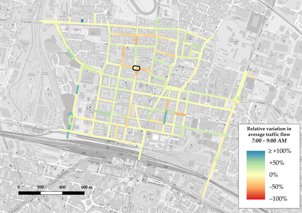
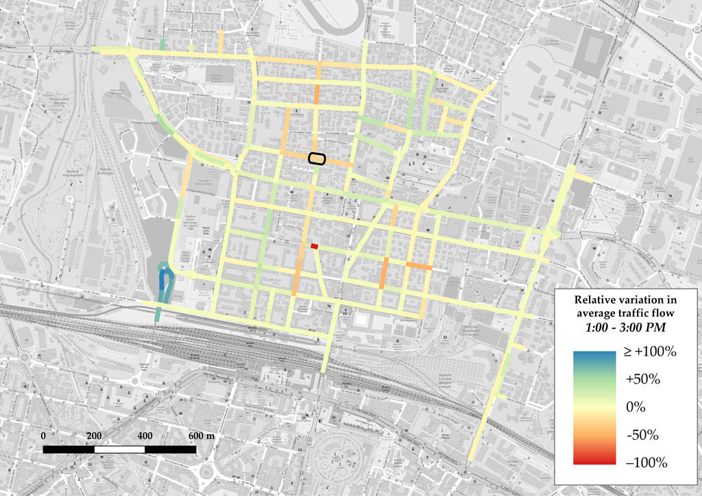
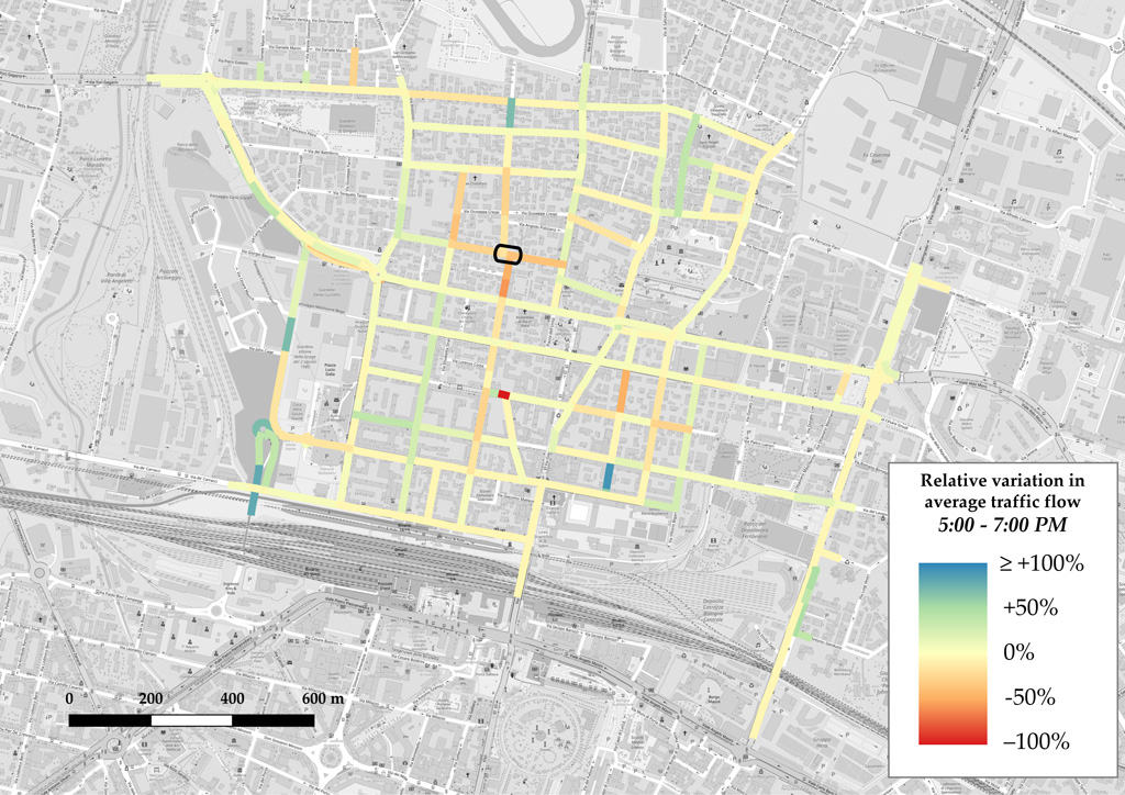
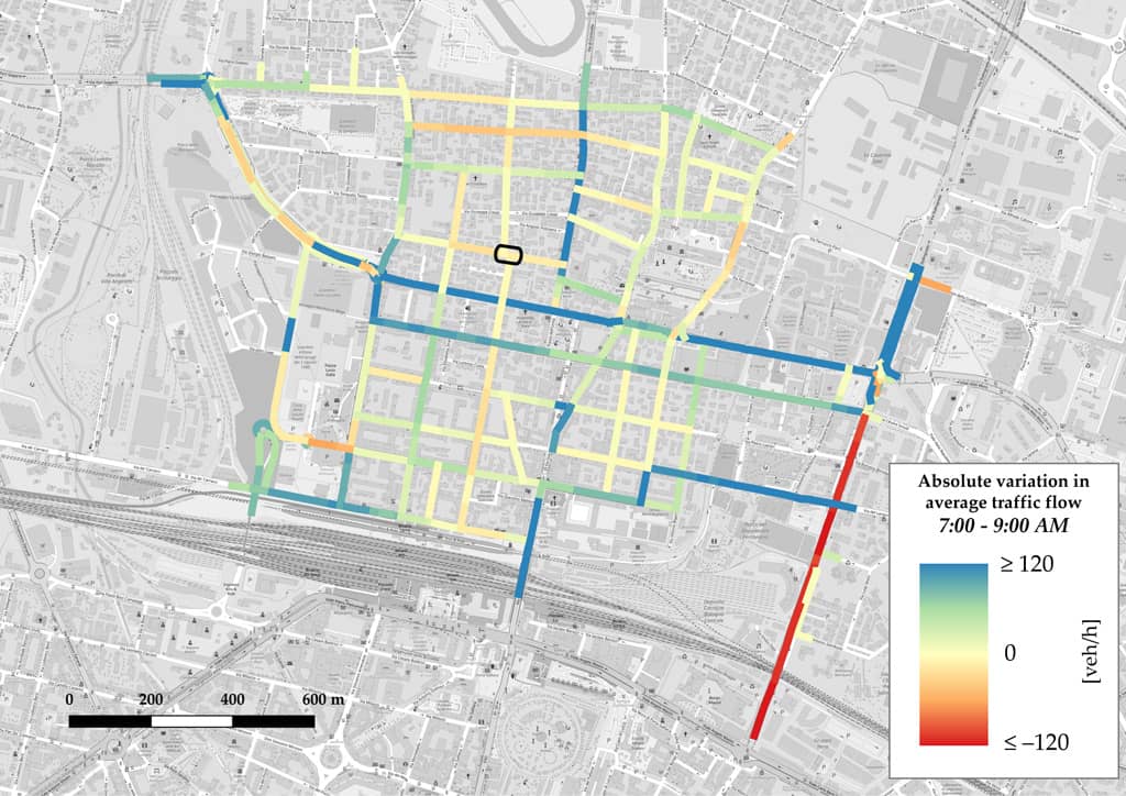
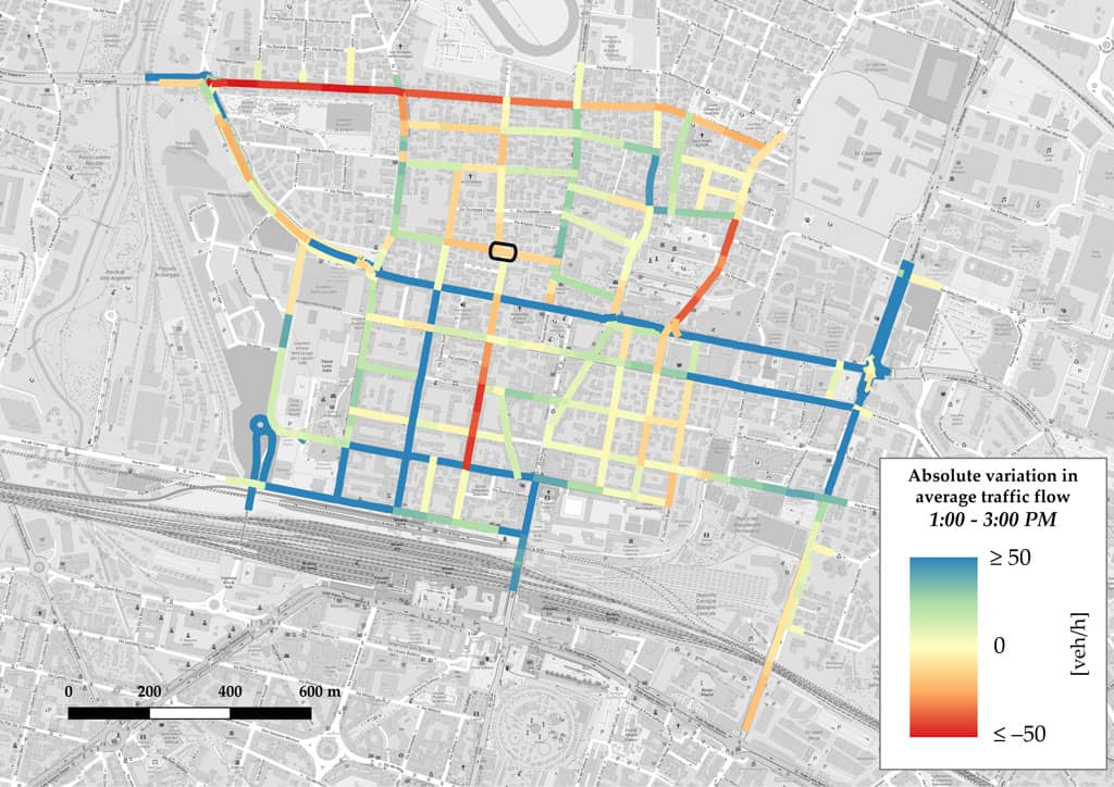
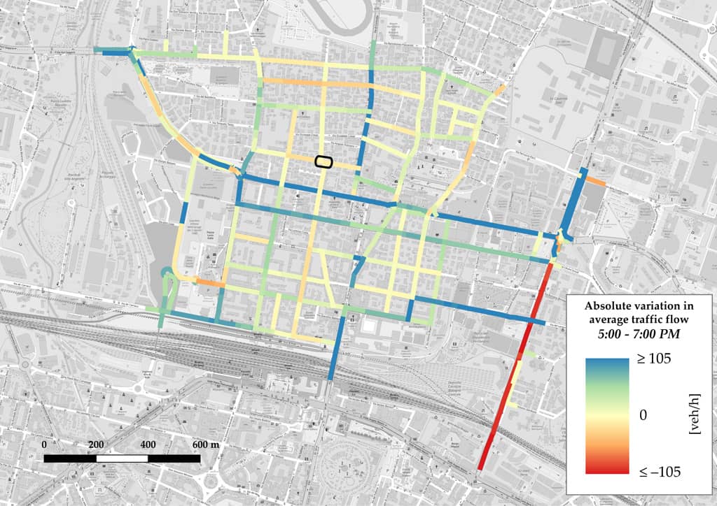
Figure 4 Results of the TomTom floating car data analysis (meso scale)
The case study in Bologna demonstrated that tactical urbanism offers contemporary cities a mechanism to test rapid, reversible public space transformations. However, its long-term value depends on embedding interventions within structured learning processes that observe outcomes and inform public policy. Public space evaluation cannot be limited to financial cost or media visibility; it must assess genuine accessibility, social encounter, and everyday residential quality. Moving beyond treating tactical urbanism as temporary event-making, cities must treat interventions as spatial inquiries. Systematic monitoring transforms temporary actions into strategic planning instruments, bridging the transition from temporariness to permanent, inclusive, and evidence-based urban transformation.
The results of this research have been published in the scientific Journal Urbanistica Informazioni: Gorrini, A., & Scarponi, L. (2026). Il monitoraggio come strumento di programmazione. In C. Amato & F. P. Mondelli (a cura di), Urbanistica tattica: pratiche, sperimentazioni e prospettive [Sessione speciale]. Urbanistica Informazioni, (328), 109–113. INU Edizioni. ISSN n. 0392-5005. https://www.inuedizioni.com/it/prodotti/rivista/n-328-urbanistica-informazioni-luglio-agosto-2026
Acknowledgments
The authors express their gratitude to Chiara Amato and Francesca Paola Mondelli, co-editors of the Special Issue of the Journal Urbanistica Informazioni, titled “Tactical Urbanism: Practices, Experimentation, and Perspectives”. Special thanks are also due to the Municipality of Bologna and Fondazione IU Rusconi Ghigi for their fruitful collaboration, and to citiEU Consultancy LTD for providing access to TomTom data.
The analyzed data were treated according to the GDPR-General Data Protection Regulation (EU, 2016/679). This research received no specific grant from any funding agency in the public, commercial, or not-for-profit sectors.
During the preparation of this work, the authors used ChatGPT to initially structure the text, and enhance clarity and readability of the manuscript. After using this tool, the authors manually reviewed and thoroughly edited all generated outputs and take full responsibility for the content of the research and publication.
References
Abdelfattah, L., Boni, G., Carnevalini, G., Choubassi, R., Gorrini, A., Messa, F., Presicce, D. (2021). A user-centric approach to the 15-minute city. Examining children’s walkability in Bologna. In: Proceedings of the 57th ISOCARP World Planning Congress 2021 (ISOCARP 2021), 8-11 November 2021, Doha (Qatar), 582-591. Available at: https://doha2021.dryfta.com/programme/discussions/sponsor-lounge/proceedings
Appleyard, D. (1981). Livable streets. University of California Press.
Ceccarelli, G., Messa, F., Gorrini, A., Presicce, D., & Choubassi, R. (2023). Deep Learning Video Analytics for the Assessment of Street Experiments: The Case of Bologna. Journal of Urban Mobility, 4, 100067. https://doi.org/10.1016/j.urbmob.2023.100067
Crenshaw, K. (1989). Demarginalizing the intersection of race and sex: A Black feminist critique of antidiscrimination doctrine, feminist theory and antiracist politics. University of Chicago Legal Forum, 1989(1), 139–167.
Gehl, J., & Svarre, B. (2013). How to study public life. Island Press.
Gifford, R. (2016). Research methods for environmental psychology. John Wiley & Sons.
GDCI-Global Designing Cities Initiative (2022). How to evaluate street transformations: A focus on pop-up and interim road safety projects. https://globaldesigningcities.org/publication/how-to-evaluate-street-transformations-english/
GDCI-Global Designing Cities Initiative (2020). How to implement street transformations: A handbook for expanding space for pedestrians and cyclists. https://globaldesigningcities.org/publication/how-to-implement-street-transformations/
Gorrini, A., Presicce, D., Messa, F., Choubassi, R. (2023). Walkability for Children in Bologna: Beyond the 15-minute City Framework. Journal of Urban Mobility, 3, 1-10. https://doi.org/10.1016/j.urbmob.2023.100052
Kandt, J., & Batty, M. (2021). Smart cities, big data and urban policy: Towards urban analytics for the long run. Cities, 109, 102992. https://doi.org/10.1016/j.cities.2020.102992
Lydon, M., & Garcia, A. (2015). Tactical urbanism: Short-term action for long-term change. Island Press.
Pozzoni, M., Ceccarelli, G., Gorrini, A., Manenti, L., Sanfilippo, L. (2023). TomTom Data Applications for the Assessment of Tactical Urbanism Interventions: The Case of Bologna. Sustainability, 15, 12716. https://doi.org/10.3390/su151712716
Whyte, W. H. (1980). The social life of small urban spaces. Project for Public Spaces.