
The research was aimed at defining an innovative nature-based approach to effectively tackle vehicle emissions by considering the role of urban green areas, relying on the capacity of trees to absorb pollutants. The project combined two datasets describing the city of Milan (Italy) in relation to public trees inventory and private transport pollutants. A series of open and proprietary data was collected and analyzed to develop a GIS model, including green areas and traffic volumes. The main outcomes of the research are: (i) developing a GIS model linking public greenery environmental performance with vehicle-related PM2.5 emissions, allowing analysis, mapping and visualizations of datasets; (ii) defining green spaces provision in terms of trees necessary to absorb the rate of pollutants emitted by vehicles. Such integrated data-driven research could support decision makers in the integrated planning of SUMPs and Urban Green Infrastructures (UGI) to leverage on their co-benefits for climate change mitigation and adaptation.
Conceptual Framework
Most of the EU cities are faced with increasing levels of traffic congestion, energy dependency, and air pollution. According to the World Health Organization, this represents the main environmental risk in Europe, affecting mainly people who live in urban areas. Encouraging sustainable mobility strategies through public transport, shared and micro mobility, and active modes of travel is one of the most essential but challenging tasks for these cities (United Nations, 2018; Buhrmann et al., 2019), among which is the development of strategies directly linked to the UN’s SDG11-Sustainable Cities and Communities and the SGD 13-Climate Action (see Figure 1).

Urban mobility indicators (e.g., road network, distance to major roads, traffic density, etc.) explain a large proportion of the variability over time in the levels of environmental exposures such as air pollution, noise, temperature, and green space (Nieuwenhuijsen, 2016). Together with Ozone, fine particulate matter (PM2.5) resulting from vehicular traffic is considered the most threatening secondary air pollutants in cities, causing the most substantial health problems and premature mortality (European Environment Agency, 2019).
This has become even more crucial considering the unprecedented long-term effects of the Covid-19 pandemic on urban mobility, as characterized by a drastic decrement in the usage indicators of public transport systems. The guidelines recently proposed by the European Platform on Sustainable Urban Mobility Plans (2020) provided examples of short-term transport planning interventions to face this critical situation. This includes the implementation of Nature-based Solutions to mitigate air pollution.
Increasing urban green areas and promoting urban forestry strategies have significant potential to decrease the vulnerability and enhance the resilience of cities in light of climatic change, thanks to capability of plant species (especially trees) to sequester huge amounts of carbon dioxide and remove PM2.5 and PM10 particulate matter and other pollutants such as NOx, while producing oxygen and lowering the temperature of the surrounding environment. Urban green spaces, from point trees to large natural spaces, provide significant ecosystem services to humans, capable of delivering significant benefits to the psycho-physical health of communities. The environmental performances of green areas are directly related to their size, condition, and quality, together with the characteristics of the tree species. Finally, the capacity of tree species to mitigate atmospheric pollutants directly depends on their physiological (i.e., stomatal conductance) and morphological (i.e., trichomes, waxes) leaf and canopy traits (Baraldi et al., 2019). Balancing urban forest density, particularly in areas of high traffic density, would greatly improve both local and city-wide urban air quality, which is why traffic and transport management issues are strictly linked to Nature-based Solutions as a strategy to improve the air quality in our cities.
From a general point of view, the investigation of air quality issues is a complex field of study, that requires knowledge from a cross-disciplinary approach considering the variety of relevant skills (e.g., environmental science, applied mathematics, urban planning, traffic engineering, etc.). The use of advanced satellite/ sensing applications is becoming a consolidated and successful domain, thanks to its scientific relevance and its capability to provide practical solutions for supporting public institutions. However, there is still a lack of knowledge about air quality modelling techniques due to the absence of standard guidance for data collection and practical restrictions in performing more extended/ granular studies relying on multiple monitoring stations.
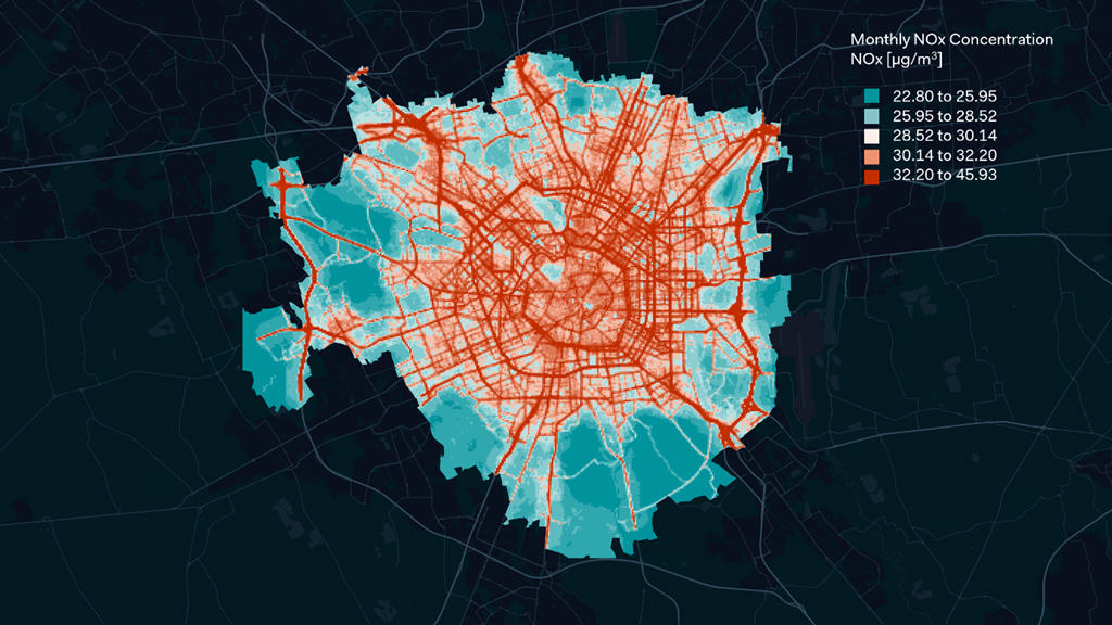
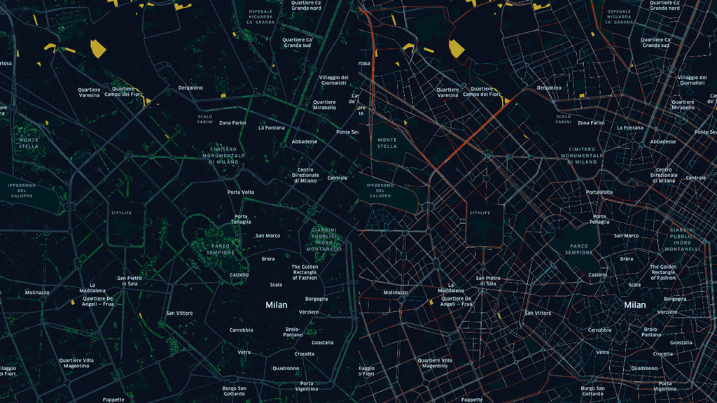
In this framework, one of the most innovative examples of air quality data collection campaign is represented by the study recently proposed by the non-profit association Cittadini per l’Aria and the consultancy ARIANET S.r.l. (Calori et al., 2018). This was based on a modeling system to estimate the impact of emissions from diesel-powered vehicles circulating in Milan on annual average NO2 concentrations (see Figure 2). The model took into account the dispersion of emitted pollutants and the chemical transformations that occur in the atmosphere as a function of meteorology. Emissions from vehicular traffic in the city of Milan were estimated using information provided by AMAT-Agenzia Mobilità, Ambiente e Territorio of the Municipality of Milan and the COPERT methodology (European Environment Agency, 2019). The study was based on participatory science actions carried out by citizens of Milan in 2017. In particular, 219 passive NO2 samplers were deployed in front of homes, or schools, or workplaces, on a pole at a height of 2.5 meters. Such experimental information was combined with the one provided by the monitoring network operated by ARPA Lombardia.
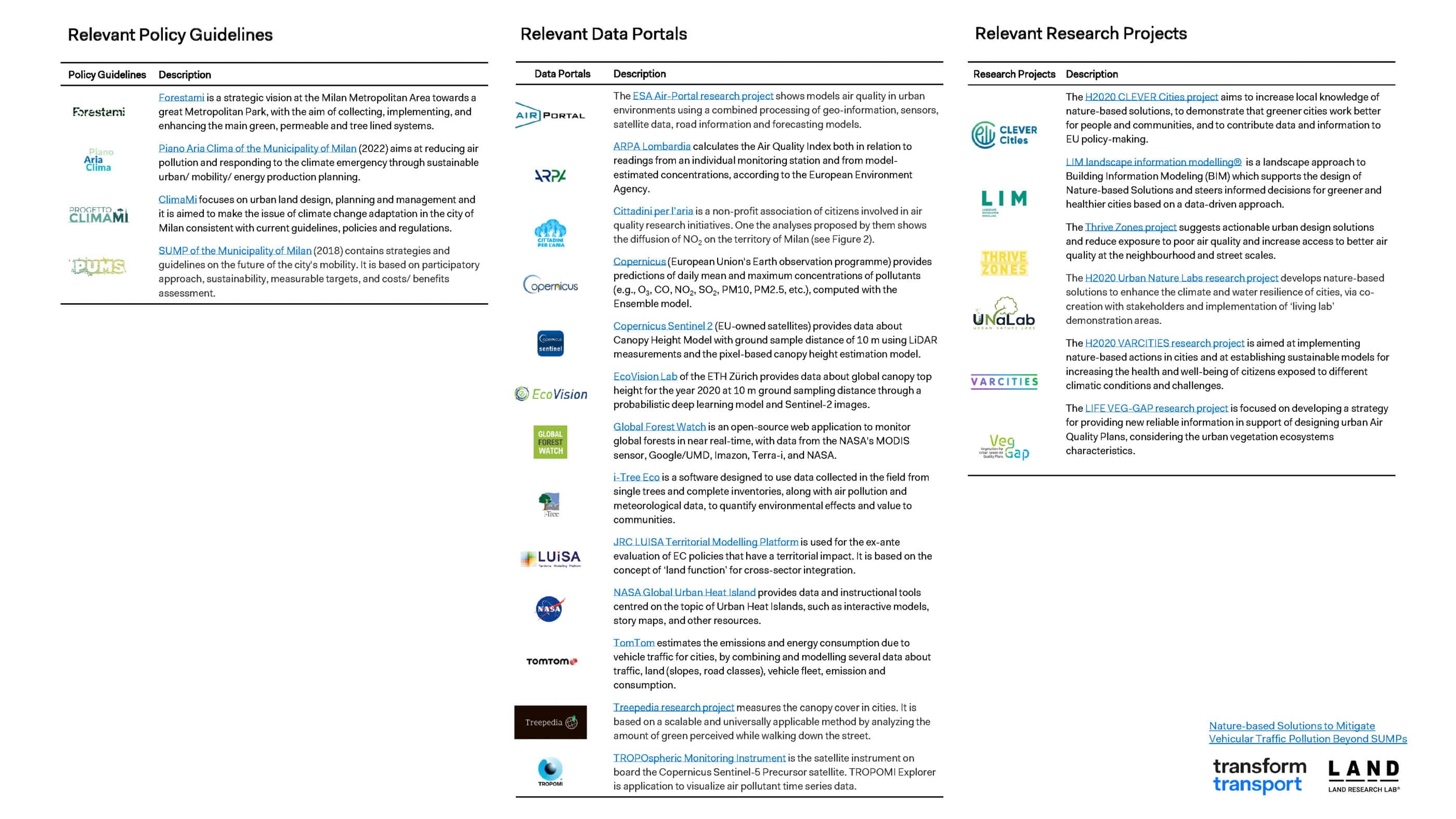
Relevant Policy Guidelines, Data Portals & Research Projects
Objectives
The proposed research was aimed at selecting typologies of Nature-based Solutions (European Commission, 2021a) capable to mitigate over time the traffic emissions in order to have a healthy and livable city where pollutants generated by vehicle emissions are reduced by both developing integrated Sustainable Urban Mobility Plans (SUMPs) and increasing tree species able to absorb them. The research combined two main typologies of data: (i) trees in public urban areas and their characteristics and performance (e.g., dimensions, localization, species, capacity to remove atmospheric pollutants, etc.); (ii) estimated level of transport-related PM2.5 emissions (e.g., traffic flows, vehicle characteristics, estimated emissions, etc.).
According to the methodological framework proposed by the European Commission (2021b), the research was based on GIS-Geographic Information Systems analysis on green areas and transport pollutants. GIS-based techniques were applied to produce cartographic analysis and thematic maps based on geo-referenced structured data sets regarding the environmental and mobility characteristics of urban areas, focusing on the case study of Milan, Italy. The study originated from the goal to find a feasible GIS-based methodology to calculate air pollutants produced by traffic and compare them with the air pollutant removal capacities provided by the different tree species on site.
Starting from an overview of the type of trees already planted in the city of Milan and considering their performances in terms of ecosystem services (e.g., Kg/year of carbon stored, Kg/year of pollutants removed, etc.), the methodology links air pollutants by transport modes to the capacity of trees to remove them both on neighborhood and city wide scale.
Considering air quality parameters related to the fine particles (i.e., PM2.5), as one of the most harmful pollutants affecting both respiratory and cardiovascular system functions, the main objective of the research was to obtain a projection of green spaces (especially trees) necessary to absorb the rate of pollutants generated by on-road vehicles. The calculation of pollutant emission of traffic flows took into account diesel-powered trucks and cars (from EURO 0 to EURO 6), as one of the most harmful category of vehicles in terms of pollutant emissions in urban centers.
Enabling Data
The research started from the analysis of the census database concerning the trees present in Milan (SIT-Geoportal of the City of Milan, 2021), which includes the following information:
- Data on the species and location of more than 250.000 trees, implemented and regularly updated by the Green Maintenance Unit of the Municipality of Milan;
- Data regarding the biometric values of green areas (i.e., height, trunk, canopy diameter);
- Additional values and parameters calculated by using the i-Tree Eco software (see Table 1) including but not limited to the following: (i) Carbon storage, the amount of carbon stored in the tissues of a tree; (ii) Pollutants removal, the amount of grams of pollutants removed; (iii) Oxygen production – amount of oxygen produced by each tree.

The above-mentioned data has therefore served as the basis for the research. Each single species was exported from the general database (see Figure 3). Data analysis showed that the five best performing tree species from the point of view of pollutant uptake are the following:
- Acer platanoides (Norway maple) – more than 27,400 units;
- Betula pendula (Silver birch) – more than 1,180 units;
- Celtis Australis (European nettle tree) – more than 14,600 units;
- Tilia cordata (Small-leaved lime) – more than 19,400 units;
- Ulmus minor (Field elm) – more than 12,200 units.

It is interesting to highlight that the performances of the previously mentioned species are remarkable, to such an extent that some exemplars of Tilia cordata (Small-leaved lime) reach almost 3000 kg of carbon sequestrated, several Betula Pendula (Silver birch) reach 5900 kg, while some Celtis australis (European nettle tree) reach the extraordinary amount of 7300 kg.
The research work was expanded thanks to the collaboration with LAND Research Lab®, the research and innovation unit of LAND Group which focuses on emerging trends and technologies for landscape development. The Lab aims to identify collaborative procedures and data-driven methodologies to make cities and rural areas more liveable, climate-proof and resource-efficient by reconnecting people with nature. Special services provided are design and assessment of Nature-based Solutions, green infrastructure planning, sustainability strategies, participative public space ideation and cooperation within European research networks.
Research projects and strategies have been developed also in-house, such as the LIM landscape information modelling® (see Figure 4), a landscape approach to Building Information Modeling (BIM) which supports the design of Nature-based Solutions and steers informed decisions for greener and healthier cities based on a data-driven approach. LIM was co-financed by the Chamber of Commerce of Milano, Lodi, Monza and Brianza under the call “Bando Qualità dell’Aria-Imprese 2030”.
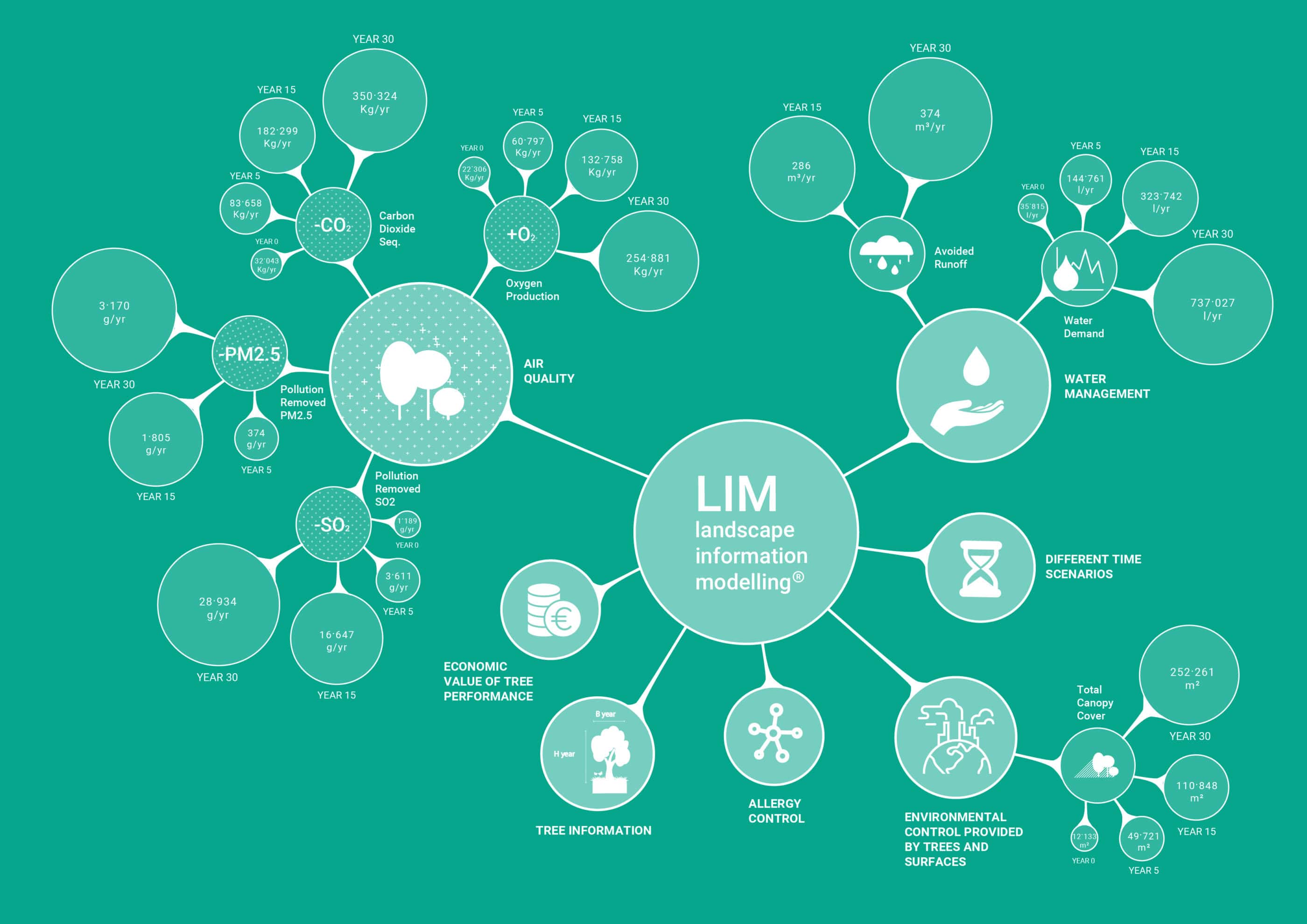
The application of the LIM was aimed at systematising date from the census of the green areas in Milan (SIT-Geoportal of the City of Milan, 2021) and the other data sources described above, allowing to create a spatial information model to quantify environmental parameters, and opening up the possibility of simulating future green growth scenarios and building a pre-assessment of sustainability to support design decisions. In particular, the use of LIM was focused on the definition of the average performance of each tree species to absorb the rate of pollutants emitted by vehicles, with reference to PM2.5-fine particulate matter. Thus, a new database was created containing the annual PM2.5 sequestration of each species according to DBH-Diameter at Breast Height classes. Moreover, the use of LIM allowed the easy data visualization of the environmental performance on the existent scenario, compatible with GIS integration.
The second part of the research was focused on the calculation of pollutants resulting from motorized traffic in Milan. This was based on a proprietary dataset of Systematica S.r.l., which includes the bidirectional vehicular flows of every single link of the road network during a morning peak hour (see Figure 5). The multimodal model, based on Cube Voyager software, has been calibrated at both the private traffic level and the public transport level through count databases provided by public entities and spot traffic survey campaigns. The model includes only aggregate information about traffic volumes, not referring to the type of vehicle (e.g., cars, commercial vehicles, heavy vehicles, etc.), nether less to the power supply (e.g., gasoline, diesel, etc.). This data were obtained from official information about the car fleet circulating in Milan (Automobile Club d’Italia, 2021).

Then, the proposed methodology was based on the definition of the yearly traffic volumes on the road network (10 hours per day, 290 days per year) and on the calculation of the pollutants emitted by diesel-powered vehicles (trucks and cars), with particular reference to PM2.5. To this end, the methodology relied on standard metrics for road infrastructures implementation proposed by Regione Lombardia (2014) and on the Air Pollutant Emission Inventory Guidebook of the European Environment Agency (2019), as follows:
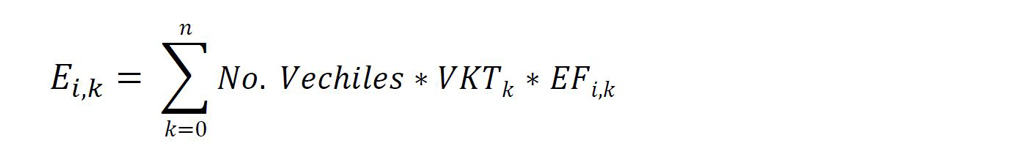
- E: emission of pollutant i, for each type of vehicle k [g/year];
- I: pollutant (i.e., PM2.5);
- K: type of vehicle;
- VKT: vehicle activity [km/year];
- EFi,k: emission factor [kg/year].
Results and Future Work
Figure 6 shows the average performance of each tree species to absorb the rate of fine particles emitted by vehicles (and their DBH-Diameter at Breast Height values) and the annual PM2.5 emissions of all diesel-powered cars (from EURO 0 to EURO 6). It is interesting to highlight that the highest values are understandably concentrated along the peripheral routes connecting Milan to the municipalities of the metropolitan area. On the other hand, emissions are significantly lower in the central part of the city, thanks also to the introduction of Area C, which is a Limited Emission Zone established to discourage the use of the most polluting private motor vehicles, reduce pollution, and derive funds for investment in public transportation.
Trees, through their physiological processes, provide a variety of ecosystem services. This term basically denotes the multiple benefits that humankind and the environment receives, directly or indirectly, from ecosystems. These includes provisioning services such as food and water; regulating services that affect climate, floods and air quality, and supporting services such as pedogenesis and nutrient cycling (Millennium Ecosystem Assessment, 2005). Plants are also able to capture huge amounts of carbon dioxide, produce oxygen, reduce PM2.5 particulate matter, and lower the temperature of the surrounding environment during the hottest and sultry summers. It is important to highlight that there are plants that are better suited than others to reduce air pollution. In this sense, their presence should be increased in large urban centres such as Milan, from urban parks to private green areas.
The future developments of the research work will be focused on:
- Extend the research to quantify others traffic-related pollutants and the capacity of public green space to mitigate them, in order to have an even more integrated tool to support public authorities in tackling air quality issues in urban areas.
- Enable the projection of urban trees characteristics according to different future scenarios, allowing to assess the potential increase in ecosystem services delivery due to vegetation growth. This will support local authorities to achieve short, medium and long-term goals related to the Sustainable Development Goals (SDGs);
- Estimate the extent and composition of urban green spaces necessary to remove the rate of pollutants emitted by vehicles in the given scenarios (Testi, 2022). The calculation of pollutant emission will consider the mobility strategies defined by the SUMP of the Municipality of Milan (2018) and the Piano Aria Clima of the Municipality of Milan (2022);
- Identify new urban areas or particularly polluted urban areas where to suggest the planting of tree species based on their specific absorption capacity. This will consider the open space development defined by the Territorial Administration Plan of the Municipality of Milan (2020);
- Promote the creation of new afforestation areas, on the outskirts of the city of Milan, by deploying most performing trees in terms of air quality improvement and climate adaptation. This will consider indications provided by Municipal Ecological Network, Metropolitan Strategic Plan and Regional Landscape Plan.
As a final step of the research, a neighborhood scale project could be produced to measure the effects of forestation into the city, focusing on:
- Finding an innovative method to control over time the emissions in order to have a clean and sustainable urban environment where traffic pollutants are reduced and green areas increased in order to leverage on their co-benefits for climate adaptation and mitigation;
- Contributing through existing monitoring platforms to involve civil society (e.g., citizens, local organizations, NGOs) in the measuring of air pollutants, assessment of environmental quality, co-creation of mapping and promotion of sustainable mobility measures;
- Producing co-created intra-sectoral planning guidelines and tools to support city authorities and practitioners in the decision making process of urban green infrastructures integrated into SUMPs.
The results of this research activity have been presented at the International Conference Smart and Sustainable Planning for Cities and Regions: Gorrini, A., Messa, F., Presicce, D., Attardi, V., Deponte, D., Balestrini, A., Schiavo, F., Pirosa, L.C., and Pallotta, D. (2022). Nature-based Approach to Mitigate Vehicular Traffic and Air Pollution Beyond SUMPs. In: 4th International Conference Smart and Sustainable Planning for Cities and Regions 2022 (SSPCR 2022), 19-22 July 2022, Bolzano (Italy). https://doi.org/10.5281/zenodo.6778749
Acknowledgment
The research was conducted in collaboration with the LAND Research Lab®. We thank the Municipality of Milan and Cittadini per l’Aria for sharing data. We also thank Arantxa DeLaHoz and Matteo La Torre for their contributions in data analysis. The analyzed data were treated according to the GDPR-General Data Protection Regulation (EU, 2016/679). This research received no specific grant from any funding agency in the public, commercial, or not-for-profit sectors.
References
Baraldi, R., Chieco, C., Neri, L., Facini, O., Rapparini, F., Morrone, L., Rotondi, A., Carriero, G., (2019). An integrated study on air mitigation potential of urban vegetation: From a multi-trait approach to modeling. Urban Forestry & Urban Greening, 41, 127-138. https://doi.org/10.1016/j.ufug.2019.03.020
Buhrmann, S., Wefering, F., Rupprecht, S. (2019). Guidelines for Developing and implementing a sustainable urban mobility plan – 2nd edition. Rupprecht Consult-Forschung und Beratung GmbH. Available at: https://www.eltis.org/mobility-plans/sump-guidelines
Calori, G., Nanni, A., Pepe, N., Silibello, C. (2018). Effettuazione di simulazioni relativi a scenari di riduzione dei veicoli diesel nella città di Milano. ARIANET S.r.l. Available at: https://www.cittadiniperlaria.org/wp-content/uploads/2019/01/RapportoARIANET-compressed.pdf
European Environment Agency (2019). Air Pollutant Emission Inventory Guidebook. Technical guidance to prepare national emission inventories. Available at: https://www.eea.europa.eu/publications/emep-eea-guidebook-2019
European Commission (2021a). Evaluating the Impact of Nature-based Solutions: A Handbook for Practitioners. European Commission, Directorate-General for Research and Innovation, Directorate C – Healthy Planet, Unit C3 – Climate and Planetary Boundaries, Brussels. Available at: https://op.europa.eu/en/publication-detail/-/publication/d7d496b5-ad4e-11eb-9767-01aa75ed71a1
European Commission (2021b). Evaluating the Impact of Nature-based Solutions: Appendix of Methods. European Commission, Directorate-General for Research and Innovation, Directorate C – Healthy Planet, Unit C3 – Climate and Planetary Boundaries, Brussels. Available at: https://op.europa.eu/en/publication-detail/-/publication/6da29d54-ad4e-11eb-9767-01aa75ed71a1
European Platform on Sustainable Urban Mobility Plans (2020). COVID-19 SUMP Practitioner Briefing. CIVITAS SATELLITE CSA. Available at: https://www.eltis.org/sites/default/files/covid-19_sumppractitionersbriefing_final.pdf
Kabisch N., Korn H., Stadler J., Bonn A. (2017). Nature-Based Solutions to Climate Change Adaptation in Urban Areas—Linkages Between Science, Policy and Practice. In: Kabisch N., Korn H., Stadler J., Bonn A. (eds). Nature-Based Solutions to Climate Change Adaptation in Urban Areas. Theory and Practice of Urban Sustainability Transitions. Springer, Cham.
Millennium Ecosystem Assessment (2005). Ecosystems and Human Well-being: Synthesis. World Resources Institute, Washington. Available at: https://www.millenniumassessment.org/documents/document.356.aspx.pdf
Nieuwenhuijsen, M.J. (2016). Urban and transport planning, environmental exposures and health-new concepts, methods and tools to improve health in cities. Environmental Health, 15, S38. https://doi.org/10.1186/s12940-016-0108-1
Regione Lombardia (2014). Linee guida per la redazione di studi di Fattibilità. Available at: https://www.regione.lombardia.it/wps/wcm/connect/219e7f85-4823-468f-a4e4-4a60547b5a83/231015_Linee+Guida+Studi+Fattibilità.pdf?MOD=AJPERES&CACHEID=ROOTWORKSPACE-219e7f85-4823-468f-a4e4-4a60547b5a83-moWlwz3
Testi, I. (2022). Urban Forestry Science. Machine Learning and the City: Applications in Architecture and Urban Design, 517-520. https://doi.org/10.1002/9781119815075.ch43
United Nations (2018). World urbanization prospects, the 2019 revision. Department of Economic and Social Affairs, Population Division, United Nations Secretariat, New York. Available at: https://population.un.org/wup/
Zhang, J., Ghirardo, A., Gori, A., Albert, A., Buegger, F., Pace, R., Georgii, E., Grote, R., Schnitzler, J.P., Durner, J. and Lindermayr, C. (2020). Improving air quality by nitric oxide consumption of climate-resilient trees suitable for urban greening. Frontiers in plant science, 11, 1491. https://doi.org/10.3389/fpls.2020.549913
Zupancic, T., Westmacott, C., & Bulthuis, M. (2015). The impact of green space on heat and air pollution in urban communities: A meta-narrative systematic review (Vol. 61). Vancouver: David Suzuki Foundation. Available at: https://davidsuzuki.org/wp-content/uploads/2017/09/impact-green-space-heat-air-pollution-urban-communities.pdf