
Abstract
The research is based on an extended spatial analysis executed through the application of GIS and Space Syntax, aiming at assessing the level of walkability for children in the City of Bologna (Italy). The research was conducted in collaboration with the Department of Urban Planning of the Municipality of Bologna and the Foundation for Urban Innovations, and take advantage from the study “Proximity services for children: the case of Bologna” which was presented on May 13th, 2021, on occasion of the 6th Edition of Biennale dello Spazio Pubblico (Rome, Italy). The study started from a thematic literature review about walkability assessment criteria and tools, which highlighted that children experience the city differently than adult pedestrians, since they are more vulnerable to road accidents and they need proper infrastructures to freely play outdoors and walk independently. The GIS analysis was based on a series of relevant location-based data and it was focused on evaluating the level of usefulness, comfort, safety, and attractiveness of Bologna for children (aged between 5 to 13 years old). The proposed Walkability for Children Index (WCI) was aimed at identifying the neighbourhoods characterized by the lowest level of pedestrian friendliness in relation to the children’s needs while walking. The Space Syntax analysis was aimed at assessing the level of Spatial Accessibility (SA) of the road network surrounding a Secondary School located in the neighbourhood Navile. The considered area was selected by the Department of Urban Planning for the future implementation of an interim public space by using the tactical urbanism approach. Results helped to identify and characterize a short list of suitable areas where to prioritize interventions, so that land use strategy and transport planning could be better aligned to the child pedestrians movement opportunities in the city.
Introduction
Encouraging the shift towards sustainable urban mobility strategies based on public transport, shared-micro mobility, and active modes of travel such us walking and cycling is one of the main challenges of European cities (Buhrmann, S., Wefering, F., Rupprecht, S., 2019), since they are increasingly facing problems of traffic congestion, road safety, energy dependency, and air pollution linked to the urbanisation global trend (United Nations, 2016). In this context, advanced urban planning activities are shifting towards a focus on walkability (Speck, 2013), namely how friendly the urban environment is for walking, living, visiting, or spending time in public spaces.
The attention to pedestrian mobility started with the principles highlighted by the European Charter of Pedestrian Rights issued by the European Parliament in 1988, that focused on the need to ensure the comfort and safety of all pedestrians in urban areas. Since then, walkability has become even more crucial considering the unprecedented effects of the Covid-19 pandemic on urban mobility.
The recent activity of transport planners and decision makers includes interventions on road networks and transport services (e.g., temporary sidewalk infrastructures, queue management in transit infrastructures, interim public spaces, etc.), to guarantee the possibility to access services within a comfortable walking distance from home (i.e., 15-minute City) (Moreno et al., 2021).
Although traditional approaches about pedestrian mobility tend to focus on the spatial dimension, individual characteristics of pedestrians have a significant impact on the perceived level of walkability. As highlighted by the 2030 Agenda for Sustainable Development adopted by all United Nations Member States (United Nations, 2016) (i.e., SDG 11.2-Sustainable Transport for All), urban mobility should be designed to be more inclusive, with attention to the needs of those in vulnerable situations, women, children, persons with disabilities and older persons.
In this framework, the proposed multi-disciplinary approach is aimed at investigating walkability for children in the City of Bologna (Italy) through the application of Geographic Information Systems and Space Syntax. The research was conducted in collaboration with the Department of Urban Planning of the Municipality of Bologna and the Foundation for Urban Innovations.
Thematic Literature Review
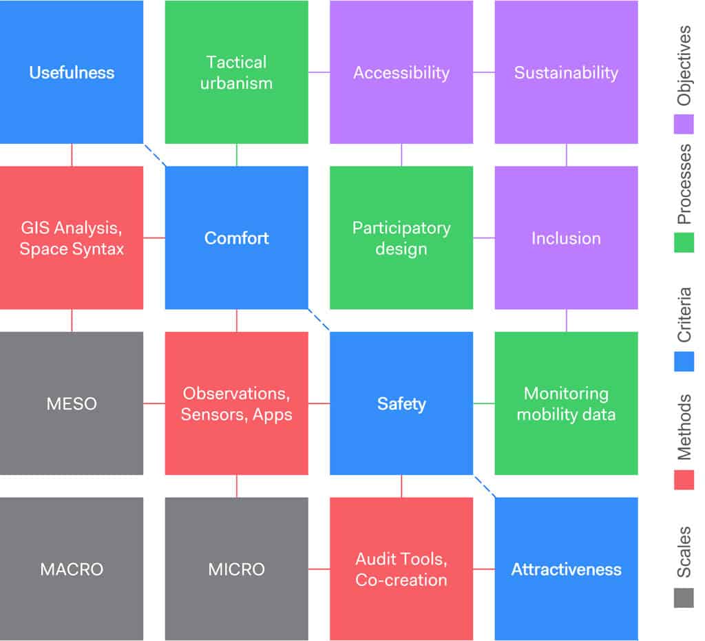
Starting from to the General Theory of Walkability proposed by Jeff Speck (2013), a thematic literature review was executed focusing on the most relevant scientific contributions about walkability assessment criteria (e.g., usefulness, comfort, safety, attractiveness) and assessment tools (e.g., GIS analysis, Space Syntax, observations, sensors, apps, audit tools, co-creation approach, etc.). The literature review was conducted through several academic database (e.g., Scopus, Google Scholar, Research Gate, etc.), and then organized in a tabular structure.
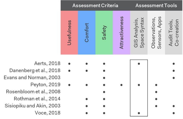
Despite recent efforts in the design of safe, comfortable, and liveable streets and public spaces for children (Aerts, 2018; Danenberg et al., 2018; Peyton, 2019), there is still a lack of knowledge regarding walkability for children, especially due to the lack of available data. Research about this topic has often been motivated by the necessity to contrasts the social costs of child pedestrian crashes. Compared to adults, children are indeed more vulnerable to road traffic collisions (World Health Organization, 2018) due to poor knowledge of regulations and the complex interaction of psychological and contextual factors.
However, various bodies of research point to the necessity of adopting a more comprehensive child-friendly urban planning approach, considering social facets of public space starting from a broader understanding of walkability. This means understanding opportunities for urban areas to provide comfort and joy as well as safe and inclusive experiences through public spaces, playgrounds, and green areas (Voce, 2018). Walkability for children includes, in fact, opportunities to freely play outdoors, walk independently and safe, and feel a sense of belonging within their neighbourhoods.
Enabling Data and Methodology
The methodological approach which sets the current research is based on the application of GIS and Space Syntax (Hiller, 1996) for the analysis of a series of relevant location-based data, which were retrieved from several open-data repositories. According to the results of the proposed thematic literature review, the considered dataset spans several domains related to the study of walkability for children.
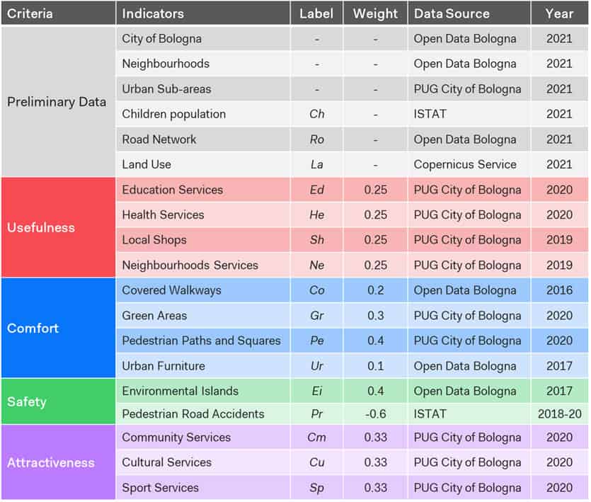
The GIS-based analysis was based on a series of isochrone maps showing lines of travel time by walking to reach each service on a 0-3 scale (considered walking speed of children = 1 meter/sec), which were combined to the calculation of the spatial distribution of each dataset on cells (ce). The analysis was aimed at assessing the level of walkability for children of the entire territory of Bologna (i.e., Macro Scale), as follows:
Level of Usefulness Index (LUI);
Level of Comfort Index (LCI);
Level of Safety Index (LSI);
Level of Attractiveness Index (LAI);
Walkability for Children Index (WCI).
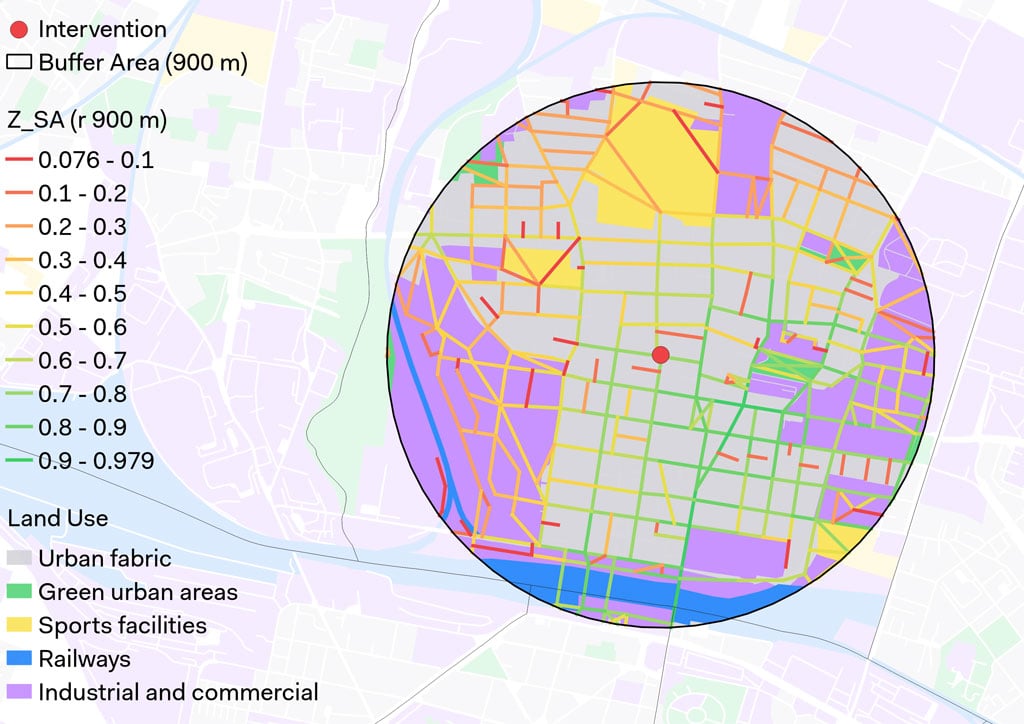
DepthmapX analysis was focused on the neighbourhood Navile (i.e., Meso scale). More precisely, it considered a parking area located nearby the Secondary School “Scuola Media Testoni”, which was selected by the Department of Urban Planning for the future implementation of an interim public space by using the tactical urbanism approach. Road network data (Ro) was extracted about a surrounding area of the school, within a catchment area of 900 m (15 minutes walking distance). This was aimed at assessing the level of accessibility of the pedestrian infrastructure surrounding the area of intervention:
Angular Integration (AIN);
Angular Choice (ACH);
Spatial Accessibility (SA).
Results
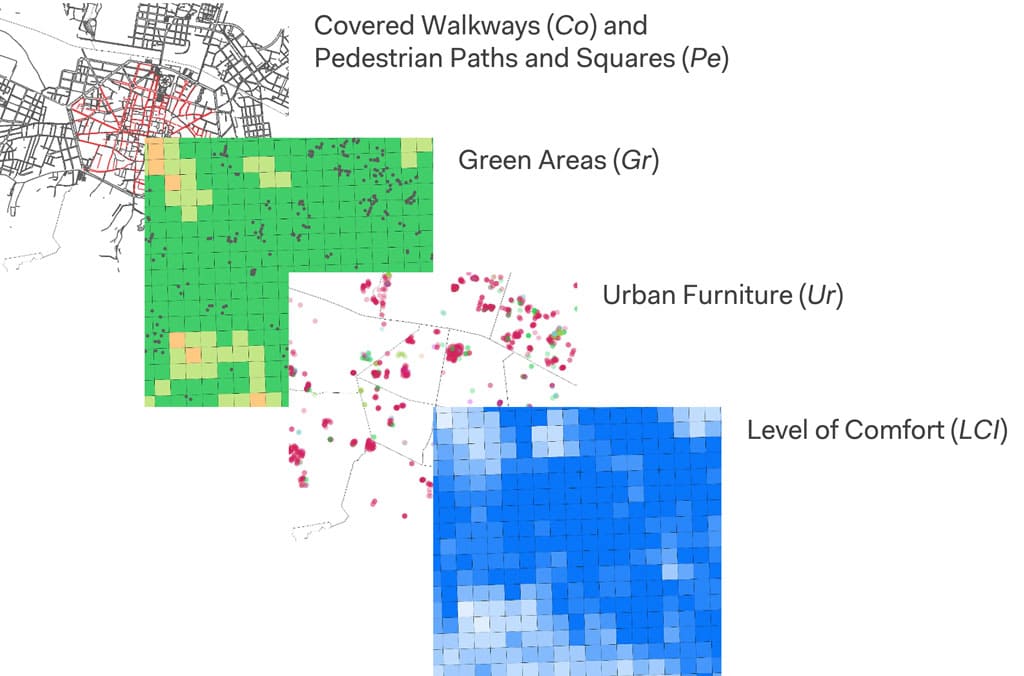
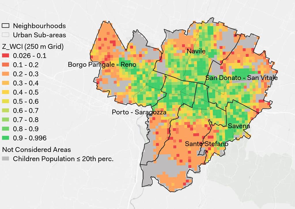
The proposed GIS-based analysis was applied to produce a cartographic analysis and a series of thematic maps focused on the walkability assessment criteria defined through the presented literature review. Results are visualized considering both the grid and the administrative boundaries of the neighbourhoods and the urban sub-areas of Bologna, with a focus on the neighbourhood Navile. Results helped to identify the cells (ce) characterized by the lowest level of usefulness, comfort, safety, and attractiveness.
Results were further analyzed to calculate the proposed Walkability for Children Index (WCI). In specifics, results helped to identify and characterize a short list of suitable urban areas of the City of Bologna where to prioritize future interventions to enhance the level of walkability for children, as mainly located in the peripheral areas of the city (WCI ≤ 0.214 – 20th percentile).
The results of the proposed Segment Analysis helped to identify the streets of the road network (Ro) characterized by the lowest level of integration and betweenness, as follows:
Angular Integration (AIN) highlighted the streets characterized by a high level of integration with the system. Integration is indicative to how many people are likely to be in a space, and is thought to correspond to rates of social encounter and retail activities;
Angular Choice (ACH) highlighted the streets characterized by a high level of global choice since located on the shortest paths from all origins to all destinations. Choice is a measure that describes the potentials for each segment element to be selected by pedestrians as the shortest path.
Then, results were further analyzed to calculate the Spatial Accessibility of the considered road network (SA), in order to identify the segments which serve as both a potential destination and route of movement. This measure narrowed the focus on fewer and more significant elements within the system that combine the attributes of being a potentially desired destination and at the same time a desired route for movement. Moreover, this spatial measure defined the type of land use that would fit best in this space, possibly certain land uses would require spaces with a high integration value.
Conclusion and Future Work
The research was aimed at investigating walkability for children through the application of Geographic Information Systems and Space Syntax. The results of the proposed Walkability for Children Index (WCI) helped to identify and characterize a short list of suitable urban areas of the City of Bologna where to prioritize future interventions. This could be focused, for example, on innovative design elements for streets and public spaces focused on both the comfort and safety of children, and on differentiated urban planning strategies aimed at guaranteeing the presence of relevant public services within a walkable distance of 15 minutes from place of residence. The results related to the Spatial Accessibility (SA) of the considered road network, can be applied to inform decision maker on the constraints and opportunities of the urban area with regard to the street network and how it can attract or deter child pedestrian movement so that land use strategy is better aligned to the pedestrian movement opportunities.
The area identified by the Municipality of Bologna for the future implementation of an interim public space (as part of the EN-UAC research project EX-TRA “EXperimenting with city streets to TRAnsform urban mobility” – Reference Number: 99950032) will be further investigated through the application of different data collection tools ex-ante and ex-post intervention (i.e., Micro Scale):
Onsite observations supported by video cameras
, aimed at producing behavioural maps by systematically noting specific pedestrians’ behaviours and movements occurring in the considered area to support the iterative design process (e.g., people counting and tracking, pedestrian flow patterns estimation, etc.);Administration of audit tools and survey questionnaires
, to collect useful information about the subjective evaluations of children about the level of walkability of the considered area.
The results of this research work have been presented at the 50th European Transport Conference 2022 (ETC 2022), 7-9 September 2022, Milan (Italy), and published in the following scientific journal: Gorrini, A., Presicce, D., Messa, F., Choubassi, R. (2023). Walkability for Children in Bologna: Beyond the 15-minute City Framework. Journal of Urban Mobility, 3, 1-10. https://doi.org/10.1016/j.urbmob.2023.100052
Acknowledgments
We thank the Municipality of Bologna and Foundation for Urban Innovations for their fruitful contribution. The analyzed data were treated according to the GDPR-General Data Protection Regulation (EU, 2016/679). This research received no specific grant from any funding agency in the public, commercial, or not-for-profit sectors.
References
Aerts, J. (2018). Shaping urbanization for children: A handbook on child-responsive urban planning. UNICEF.
Buhrmann, S., Wefering, F., Rupprecht, S. (2019). Guidelines for developing and implementing a sustainable urban mobility plan – 2nd edition. Rupprecht Consult-Forschung und Beratung GmbH.
Danenberg, R., Doumpa, V., & Karssenberg, H. (2018). The City at Eye Level. STIPO Publishing.
Evans, D., & Norman, P. (2003). Predicting adolescent pedestrians’ road-crossing intentions: An application and extension of the theory of planned behaviour. Health education research, 18(3), 267–277. https://doi.org/10.1093/her/cyf023
Hiller, B. (1996). Cities as movement economies. Urban Design International, 1(1), 41–60. https://doi.org/10.1057/udi.1996.5
Moreno, C., Allam, Z., Chabaud, D., Gall, C., & Pratlong, F. (2021). Introducing the “15-Minute City”: Sustainability, Resilience and Place Identity in Future Post-Pandemic Cities. Smart Cities, 4(1), 93–111. https://doi.org/10.3390/smartcities4010006
Peyton, A. (2019). Designing streets for kids. NACTO-Global Designing Cities Initiative.
Rosenbloom, T., Ben-Eliyahu, A., & Nemrodov, D. (2008). Children’s crossing behavior with an accompanying adult. Safety Science, 46(8), 1248–1254. https://doi.org/10.1016/j.ssci.2007.07.004
Rothman, L., To, T., Buliung, R., Macarthur, C., & Howard, A. (2014). Influence of social and built environment features on children walking to school: an observational study. Preventive Medicine, 60, 10–15. https://doi.org/10.1016/j.ypmed.2013.12.005
Sisiopiku, V. P., & Akin, D. (2003). Pedestrian behaviors at and perceptions towards various pedestrian facilities: An examination based on observation and survey data. Transportation Research Part F: Traffic Psychology and Behaviour, 6(4), 249–274. https://doi.org/10.1016/j.trf.2003.06.001
Speck, J. (2013). Walkable city: How downtown can save America, one step at a time. Macmillan.
United Nations. (2016). Transforming Our World: The 2030 Agenda for Sustainable Development. United Nations.
Voce, A. (2018). Cities alive: Designing for urban childhoods. Children, Youth and Environments, 28(2), 78–81. https://doi.org/10.7721/chilyoutenvi.28.2.0078
World Health Organization. (2018). Global status report on road safety. World Health Organization.