
Within the research activities of Transform Transport on the impact of the Covid-19 pandemic on urban mobility (see the recently published booklet ‘Shifting Paradigm’), this study is focused on the analysis of a large sample of structured proprietary data gathered during a 7-month period (January to July 2020) through a network of 55 Wi-Fi sensors distributed in several department stores, shops and public services in Milan (Italy).

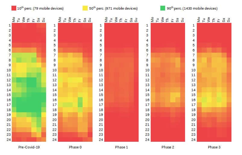
Taking advantage of a preliminary work already presented by Transform Transport, the objective of the analysis is twofold. First, the research aimed at testing the effectiveness and reliability of Wi-Fi technology to collect aggregated data about activity patterns in large scale urban scenarios. In this framework, the number of mobile devices detected per day per hour during the entire period of reference was analyzed to estimate the effects of the Covid-19 pandemic on activity patterns. In particular, a time series analysis on trends, peak hours and mobility profiles was executed to compare results between the Pre-Covid-19 period (from January 1st to February 22nd, 2020) and the lockdown Phase 0, 1, 2 and 3 (from February 23rd to July 31st, 2020).
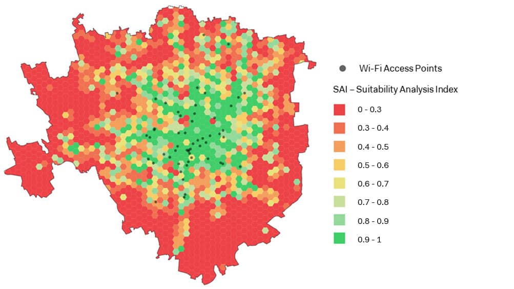
Second, the research aimed at correlating the number of detected mobile devices (i.e., time-variant data) with the density distribution of relevant land and Public Transport data (i.e., time-invariant data), such as building typologies, green areas, amenities and Public Transport. Given the unprecedented effects of the adopted containment measures on urban dynamics (e.g., restricted mobility, partial opening or closures of public services, etc.), the proposed GIS-based analysis aimed at understanding which areas of the city were more resilient during the evolution of the lockdown phases, considering the variation of Wi-Fi data during the entire period of reference.

The results of the analysis were used to define a Suitability Analysis Index (SAI), aiming at identifying the areas of Milan which could be exploited for more extensive data collection campaigns by means of the installation of additional Wi-Fi sensors.
The results of this research activity has been published in the scientific Journal TeMA: Gorrini, A., Messa, F., Ceccarelli, G. & Choubassi, R. (2021). Covid-19 pandemic and activity patterns in Milan. Wi-Fi sensors and location-based data. TeMA – Journal of Land Use, Mobility and Environment, 14 (2), 211-226. https://doi.org/10.6093/1970-9870/7886
Abstract
The recent development of location detection systems allows to monitor, understand and predict the activity patterns of the city users. In this framework, the research focuses on the analysis of a sample of aggregated traffic data, based on the number of mobile devices detected through a network of 55 Wi-Fi Access Points in Milan. Data was collected over 7 months (January to July 2020), allowing for a study on the impact of the Covid-19 pandemic on activity patterns. Data analysis was based on merging: (i) time series analysis of trends, peak hours and mobility profiles; (ii) GIS-based spatial analysis of land data and Public Transport data. Results showed the effectiveness of Wi-Fi location data to monitor and characterize long-term trends about activity patterns in large scale urban scenarios. Results also showed a significant correlation between Wi-Fi data and the density distribution of residential buildings, service and transportation facilities, entertainment, financial amenities, department stores and bike-sharing docking stations. In this context, a Suitability Analysis Index is proposed, aiming at identifying the areas of Milan which could be exploited for more extensive data collection campaigns by means of the installation of additional Wi-Fi sensors. Future work is based on the development of Wi-Fi sensing applications for monitoring mobility data in real time.